You are here: Home > Network List > US - United States National Seismic Network Stations List
> Station WMOK Wichita Mountains, Oklahoma, USA > Earthquake Result Viewer
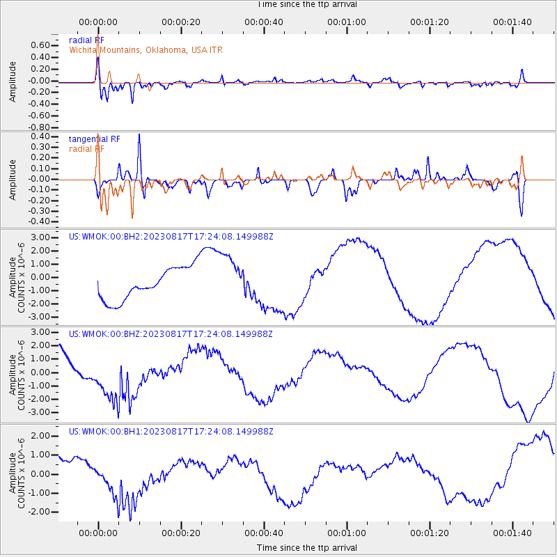
WMOK Wichita Mountains, Oklahoma, USA - Earthquake Result Viewer
*The percent match for this event was below the threshold and hence no stack was calculated.
| Earthquake location: |
Colombia |
| Earthquake latitude/longitude: |
4.2/-73.6 |
| Earthquake time(UTC): |
2023/08/17 (229) 17:17:18 GMT |
| Earthquake Depth: |
7.9 km |
| Earthquake Magnitude: |
5.7 Mww |
| Earthquake Catalog/Contributor: |
NEIC PDE/us |
|
| Network: |
US United States National Seismic Network |
| Station: |
WMOK Wichita Mountains, Oklahoma, USA |
| Lat/Lon: |
34.74 N/98.78 W |
| Elevation: |
486 m |
|
| Distance: |
38.3 deg |
| Az: |
325.584 deg |
| Baz: |
136.807 deg |
| Ray Param: |
$rayparam |
*The percent match for this event was below the threshold and hence was not used in the summary stack. |
|
| Radial Match: |
79.34292 % |
| Radial Bump: |
382 |
| Transverse Match: |
76.340416 % |
| Transverse Bump: |
299 |
| SOD ConfigId: |
31937991 |
| Insert Time: |
2023-08-31 17:55:46.377 +0000 |
| GWidth: |
2.5 |
| Max Bumps: |
400 |
| Tol: |
0.001 |
|
Signal To Noise
| Channel | StoN | STA | LTA |
| US:WMOK:00:BHZ:20230817T17:24:08.149988Z | 1.9595364 | 1.9246854E-6 | 9.822147E-7 |
| US:WMOK:00:BH1:20230817T17:24:08.149988Z | 1.0978444 | 7.715275E-7 | 7.027658E-7 |
| US:WMOK:00:BH2:20230817T17:24:08.149988Z | 1.49772 | 1.8228262E-6 | 1.2170674E-6 |
| Arrivals |
| Ps | |
| PpPs | |
| PsPs/PpSs | |


