You are here: Home > Network List > TA - USArray Transportable Network (new EarthScope stations) Stations List
> Station H20A Greybull, WY, USA > Earthquake Result Viewer
H20A Greybull, WY, USA - Earthquake Result Viewer
| Earthquake location: |
Northern Chile |
| Earthquake latitude/longitude: |
-22.1/-68.2 |
| Earthquake time(UTC): |
2010/07/12 (193) 00:11:21 GMT |
| Earthquake Depth: |
115 km |
| Earthquake Magnitude: |
6.1 MB, 6.3 MW, 6.2 MW |
| Earthquake Catalog/Contributor: |
WHDF/NEIC |
|
| Network: |
TA USArray Transportable Network (new EarthScope stations) |
| Station: |
H20A Greybull, WY, USA |
| Lat/Lon: |
44.49 N/108.00 W |
| Elevation: |
1236 m |
|
| Distance: |
75.6 deg |
| Az: |
331.784 deg |
| Baz: |
142.237 deg |
| Ray Param: |
0.051262867 |
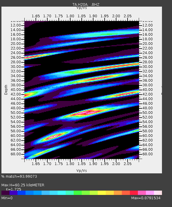
| Estimated Moho Depth: |
60.25 km |
| Estimated Crust Vp/Vs: |
1.73 |
| Assumed Crust Vp: |
6.178 km/s |
| Estimated Crust Vs: |
3.582 km/s |
| Estimated Crust Poisson's Ratio: |
0.25 |
|
| Radial Match: |
93.99073 % |
| Radial Bump: |
364 |
| Transverse Match: |
89.7006 % |
| Transverse Bump: |
372 |
| SOD ConfigId: |
319893 |
| Insert Time: |
2011-01-05 02:12:59.304 +0000 |
| GWidth: |
2.5 |
| Max Bumps: |
400 |
| Tol: |
0.001 |
|
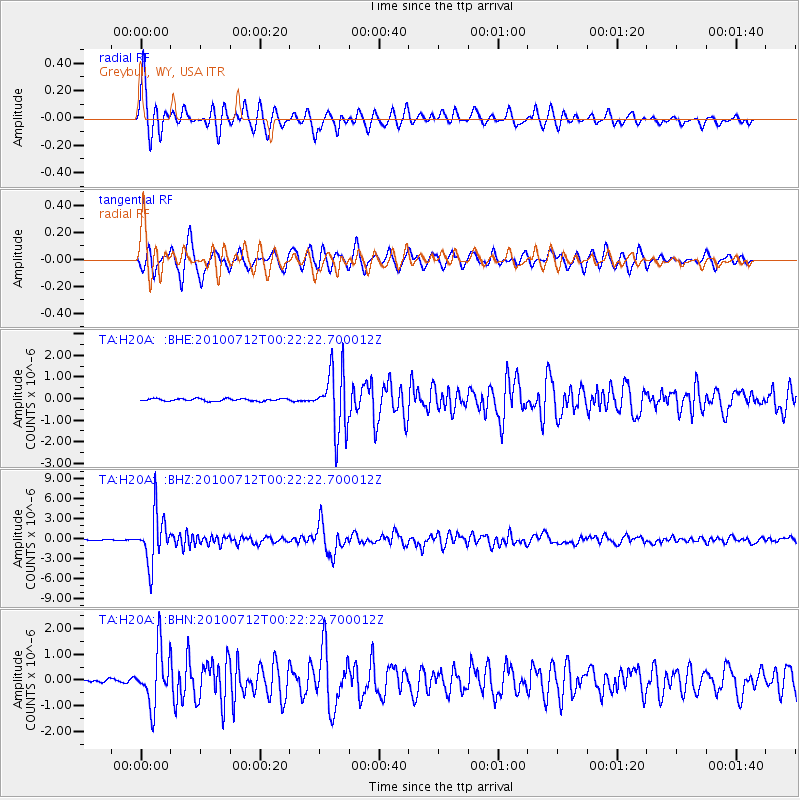
Signal To Noise
| Channel | StoN | STA | LTA |
| TA:H20A: :BHZ:20100712T00:22:22.700012Z | 60.838474 | 3.6703796E-6 | 6.032991E-8 |
| TA:H20A: :BHN:20100712T00:22:22.700012Z | 16.172836 | 1.0736651E-6 | 6.638693E-8 |
| TA:H20A: :BHE:20100712T00:22:22.700012Z | 25.273443 | 1.4145103E-6 | 5.5968243E-8 |
| Arrivals |
| Ps | 7.3 SECOND |
| PpPs | 26 SECOND |
| PsPs/PpSs | 33 SECOND |


