You are here: Home > Network List > TA - USArray Transportable Network (new EarthScope stations) Stations List
> Station F21A Absaloka Mine, Hardin, MT, USA > Earthquake Result Viewer
F21A Absaloka Mine, Hardin, MT, USA - Earthquake Result Viewer
| Earthquake location: |
Northern Chile |
| Earthquake latitude/longitude: |
-22.1/-68.2 |
| Earthquake time(UTC): |
2010/07/12 (193) 00:11:21 GMT |
| Earthquake Depth: |
115 km |
| Earthquake Magnitude: |
6.1 MB, 6.3 MW, 6.2 MW |
| Earthquake Catalog/Contributor: |
WHDF/NEIC |
|
| Network: |
TA USArray Transportable Network (new EarthScope stations) |
| Station: |
F21A Absaloka Mine, Hardin, MT, USA |
| Lat/Lon: |
45.82 N/107.12 W |
| Elevation: |
1026 m |
|
| Distance: |
76.3 deg |
| Az: |
333.127 deg |
| Baz: |
143.181 deg |
| Ray Param: |
0.05080319 |
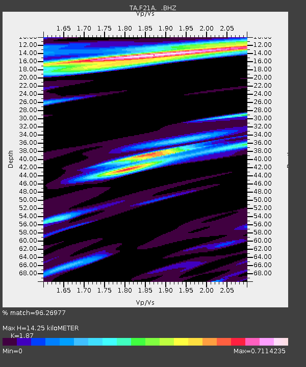
| Estimated Moho Depth: |
14.25 km |
| Estimated Crust Vp/Vs: |
1.87 |
| Assumed Crust Vp: |
6.178 km/s |
| Estimated Crust Vs: |
3.304 km/s |
| Estimated Crust Poisson's Ratio: |
0.30 |
|
| Radial Match: |
96.26977 % |
| Radial Bump: |
400 |
| Transverse Match: |
90.587906 % |
| Transverse Bump: |
400 |
| SOD ConfigId: |
319893 |
| Insert Time: |
2011-01-05 02:13:36.491 +0000 |
| GWidth: |
2.5 |
| Max Bumps: |
400 |
| Tol: |
0.001 |
|
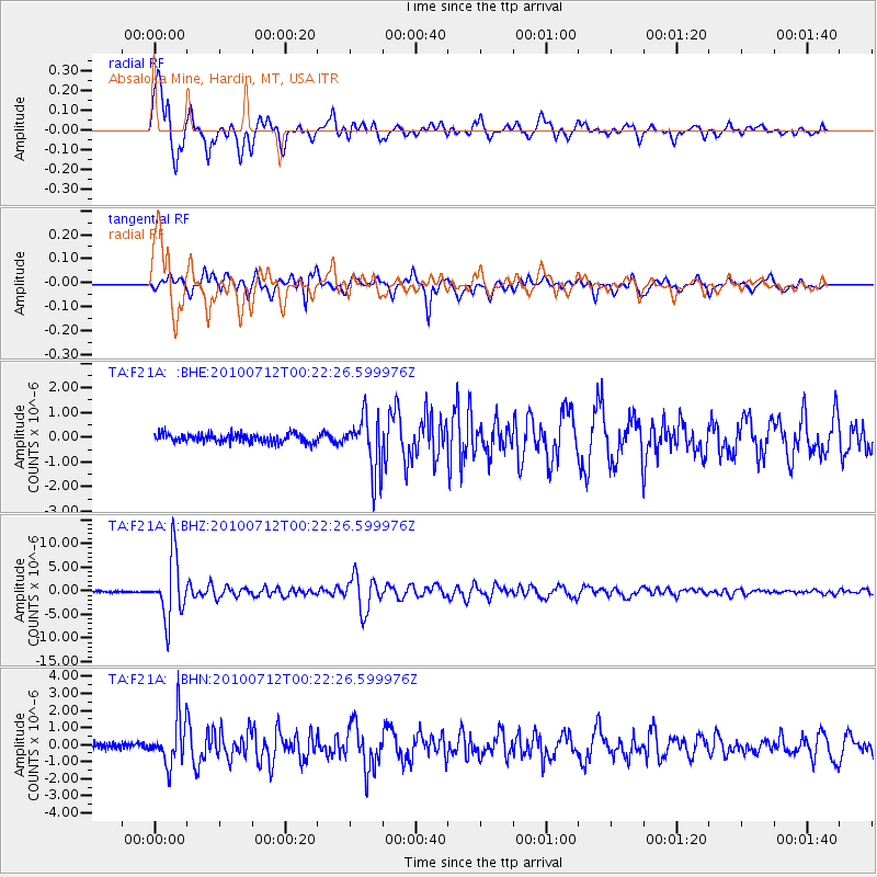
Signal To Noise
| Channel | StoN | STA | LTA |
| TA:F21A: :BHZ:20100712T00:22:26.599976Z | 47.51224 | 6.4447327E-6 | 1.3564362E-7 |
| TA:F21A: :BHN:20100712T00:22:26.599976Z | 8.065222 | 1.3202317E-6 | 1.6369441E-7 |
| TA:F21A: :BHE:20100712T00:22:26.599976Z | 6.5550346 | 1.1417909E-6 | 1.7418533E-7 |
| Arrivals |
| Ps | 2.1 SECOND |
| PpPs | 6.4 SECOND |
| PsPs/PpSs | 8.5 SECOND |


