You are here: Home > Network List > TA - USArray Transportable Network (new EarthScope stations) Stations List
> Station KMSC Kings Mountain, Blacksburg, SC, USA > Earthquake Result Viewer
KMSC Kings Mountain, Blacksburg, SC, USA - Earthquake Result Viewer
| Earthquake location: |
Northern Chile |
| Earthquake latitude/longitude: |
-22.1/-68.2 |
| Earthquake time(UTC): |
2010/07/12 (193) 00:11:21 GMT |
| Earthquake Depth: |
115 km |
| Earthquake Magnitude: |
6.1 MB, 6.3 MW, 6.2 MW |
| Earthquake Catalog/Contributor: |
WHDF/NEIC |
|
| Network: |
TA USArray Transportable Network (new EarthScope stations) |
| Station: |
KMSC Kings Mountain, Blacksburg, SC, USA |
| Lat/Lon: |
35.14 N/81.33 W |
| Elevation: |
240 m |
|
| Distance: |
58.3 deg |
| Az: |
347.375 deg |
| Baz: |
165.685 deg |
| Ray Param: |
0.0625794 |
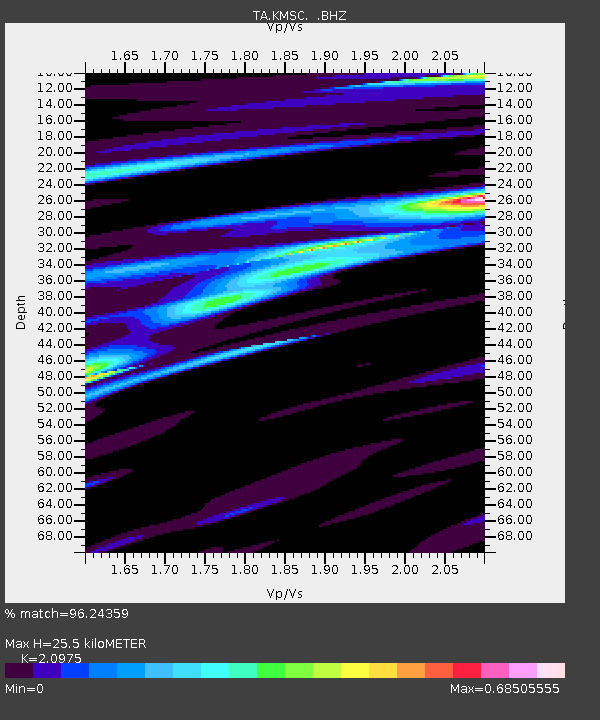
| Estimated Moho Depth: |
25.5 km |
| Estimated Crust Vp/Vs: |
2.10 |
| Assumed Crust Vp: |
6.419 km/s |
| Estimated Crust Vs: |
3.06 km/s |
| Estimated Crust Poisson's Ratio: |
0.35 |
|
| Radial Match: |
96.24359 % |
| Radial Bump: |
316 |
| Transverse Match: |
80.55552 % |
| Transverse Bump: |
400 |
| SOD ConfigId: |
319893 |
| Insert Time: |
2011-01-05 02:15:34.727 +0000 |
| GWidth: |
2.5 |
| Max Bumps: |
400 |
| Tol: |
0.001 |
|
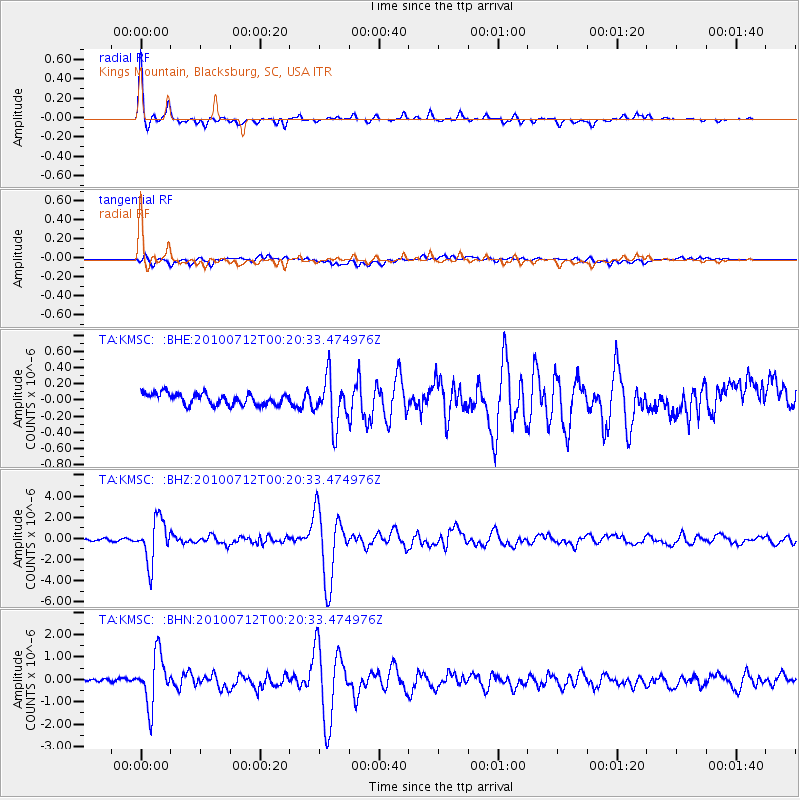
Signal To Noise
| Channel | StoN | STA | LTA |
| TA:KMSC: :BHZ:20100712T00:20:33.474976Z | 21.953886 | 2.0168354E-6 | 9.1866895E-8 |
| TA:KMSC: :BHN:20100712T00:20:33.474976Z | 12.10418 | 1.1139999E-6 | 9.203431E-8 |
| TA:KMSC: :BHE:20100712T00:20:33.474976Z | 4.1390896 | 2.9097902E-7 | 7.0300246E-8 |
| Arrivals |
| Ps | 4.5 SECOND |
| PpPs | 12 SECOND |
| PsPs/PpSs | 16 SECOND |


