You are here: Home > Network List > TA - USArray Transportable Network (new EarthScope stations) Stations List
> Station F22A Rosebud, MT, USA > Earthquake Result Viewer
F22A Rosebud, MT, USA - Earthquake Result Viewer
| Earthquake location: |
Northern Chile |
| Earthquake latitude/longitude: |
-22.1/-68.2 |
| Earthquake time(UTC): |
2010/07/12 (193) 00:11:21 GMT |
| Earthquake Depth: |
115 km |
| Earthquake Magnitude: |
6.1 MB, 6.3 MW, 6.2 MW |
| Earthquake Catalog/Contributor: |
WHDF/NEIC |
|
| Network: |
TA USArray Transportable Network (new EarthScope stations) |
| Station: |
F22A Rosebud, MT, USA |
| Lat/Lon: |
45.78 N/106.26 W |
| Elevation: |
882 m |
|
| Distance: |
75.9 deg |
| Az: |
333.602 deg |
| Baz: |
143.914 deg |
| Ray Param: |
0.05106703 |
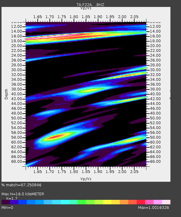
| Estimated Moho Depth: |
16.0 km |
| Estimated Crust Vp/Vs: |
1.70 |
| Assumed Crust Vp: |
6.178 km/s |
| Estimated Crust Vs: |
3.634 km/s |
| Estimated Crust Poisson's Ratio: |
0.24 |
|
| Radial Match: |
87.250946 % |
| Radial Bump: |
400 |
| Transverse Match: |
86.84663 % |
| Transverse Bump: |
400 |
| SOD ConfigId: |
319893 |
| Insert Time: |
2011-01-05 02:16:36.308 +0000 |
| GWidth: |
2.5 |
| Max Bumps: |
400 |
| Tol: |
0.001 |
|
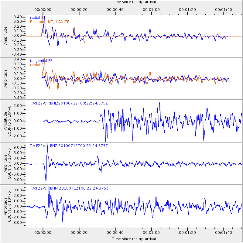
Signal To Noise
| Channel | StoN | STA | LTA |
| TA:F22A: :BHZ:20100712T00:22:24.375Z | 50.429882 | 4.3323917E-6 | 8.5909214E-8 |
| TA:F22A: :BHN:20100712T00:22:24.375Z | 12.151174 | 1.3338886E-6 | 1.0977446E-7 |
| TA:F22A: :BHE:20100712T00:22:24.375Z | 8.579845 | 8.1826664E-7 | 9.537079E-8 |
| Arrivals |
| Ps | 1.9 SECOND |
| PpPs | 6.8 SECOND |
| PsPs/PpSs | 8.7 SECOND |


