You are here: Home > Network List > TX - Texas Seismological Network Stations List
> Station PB06 Permian Basin 6 > Earthquake Result Viewer
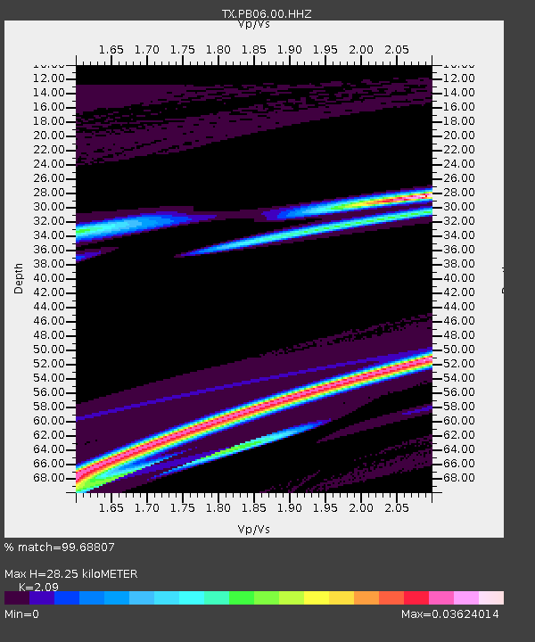
PB06 Permian Basin 6 - Earthquake Result Viewer
| Earthquake location: |
Pacific-Antarctic Ridge |
| Earthquake latitude/longitude: |
-54.3/-136.6 |
| Earthquake time(UTC): |
2023/08/06 (218) 04:04:27 GMT |
| Earthquake Depth: |
10 km |
| Earthquake Magnitude: |
5.5 Mww |
| Earthquake Catalog/Contributor: |
NEIC PDE/us |
|
| Network: |
TX Texas Seismological Network |
| Station: |
PB06 Permian Basin 6 |
| Lat/Lon: |
31.65 N/103.22 W |
| Elevation: |
831 m |
|
| Distance: |
90.3 deg |
| Az: |
27.991 deg |
| Baz: |
198.814 deg |
| Ray Param: |
0.041710574 |
| Estimated Moho Depth: |
28.25 km |
| Estimated Crust Vp/Vs: |
2.09 |
| Assumed Crust Vp: |
6.121 km/s |
| Estimated Crust Vs: |
2.928 km/s |
| Estimated Crust Poisson's Ratio: |
0.35 |
|
| Radial Match: |
99.68807 % |
| Radial Bump: |
34 |
| Transverse Match: |
99.72478 % |
| Transverse Bump: |
30 |
| SOD ConfigId: |
31937991 |
| Insert Time: |
2023-09-02 04:21:18.400 +0000 |
| GWidth: |
2.5 |
| Max Bumps: |
400 |
| Tol: |
0.001 |
|

Signal To Noise
| Channel | StoN | STA | LTA |
| TX:PB06:00:HHZ:20230806T04:16:56.549988Z | 0.6000047 | 3.0994893E-6 | 5.165775E-6 |
| TX:PB06:00:HH1:20230806T04:16:56.549988Z | 0.6025337 | 3.743661E-6 | 6.2131976E-6 |
| TX:PB06:00:HH2:20230806T04:16:56.549988Z | 0.6034966 | 2.1714116E-6 | 3.598051E-6 |
| Arrivals |
| Ps | 5.1 SECOND |
| PpPs | 14 SECOND |
| PsPs/PpSs | 19 SECOND |


