You are here: Home > Network List > TA - USArray Transportable Network (new EarthScope stations) Stations List
> Station O26A Horse Wrangler Ranch, Akron, CO, USA > Earthquake Result Viewer
O26A Horse Wrangler Ranch, Akron, CO, USA - Earthquake Result Viewer

| Earthquake location: |
Northern Chile |
| Earthquake latitude/longitude: |
-22.1/-68.2 |
| Earthquake time(UTC): |
2010/07/12 (193) 00:11:21 GMT |
| Earthquake Depth: |
115 km |
| Earthquake Magnitude: |
6.1 MB, 6.3 MW, 6.2 MW |
| Earthquake Catalog/Contributor: |
WHDF/NEIC |
|
| Network: |
TA USArray Transportable Network (new EarthScope stations) |
| Station: |
O26A Horse Wrangler Ranch, Akron, CO, USA |
| Lat/Lon: |
40.24 N/103.31 W |
| Elevation: |
1413 m |
|
| Distance: |
70.2 deg |
| Az: |
332.103 deg |
| Baz: |
145.48 deg |
| Ray Param: |
0.05487389 |
| Estimated Moho Depth: |
16.5 km |
| Estimated Crust Vp/Vs: |
1.76 |
| Assumed Crust Vp: |
6.483 km/s |
| Estimated Crust Vs: |
3.673 km/s |
| Estimated Crust Poisson's Ratio: |
0.26 |
|
| Radial Match: |
93.21467 % |
| Radial Bump: |
388 |
| Transverse Match: |
73.429565 % |
| Transverse Bump: |
400 |
| SOD ConfigId: |
319893 |
| Insert Time: |
2011-01-05 02:17:12.526 +0000 |
| GWidth: |
2.5 |
| Max Bumps: |
400 |
| Tol: |
0.001 |
|
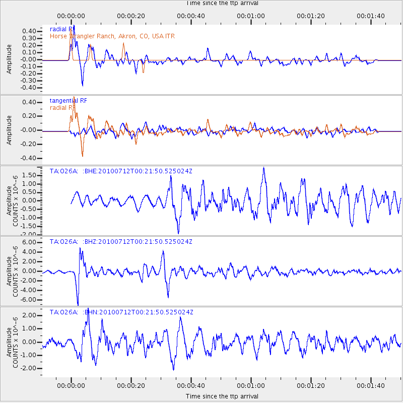
Signal To Noise
| Channel | StoN | STA | LTA |
| TA:O26A: :BHZ:20100712T00:21:50.525024Z | 20.557182 | 2.900955E-6 | 1.4111637E-7 |
| TA:O26A: :BHN:20100712T00:21:50.525024Z | 2.7450852 | 7.448496E-7 | 2.7133933E-7 |
| TA:O26A: :BHE:20100712T00:21:50.525024Z | 2.2080367 | 5.484225E-7 | 2.4837564E-7 |
| Arrivals |
| Ps | 2.0 SECOND |
| PpPs | 6.8 SECOND |
| PsPs/PpSs | 8.8 SECOND |


