You are here: Home > Network List > WY - Yellowstone Wyoming Seismic Network Stations List
> Station YHH Holmes Hill, YNP, WY, USA > Earthquake Result Viewer
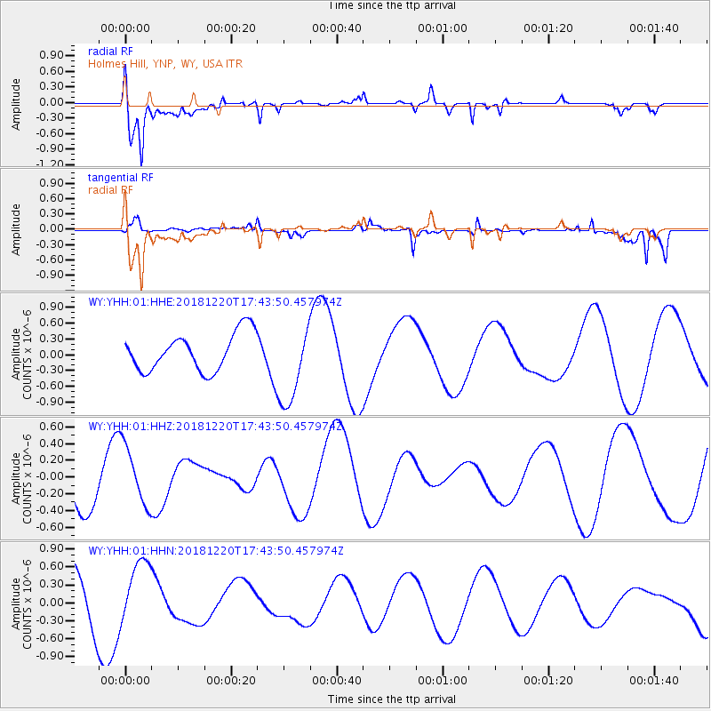
YHH Holmes Hill, YNP, WY, USA - Earthquake Result Viewer
*The percent match for this event was below the threshold and hence no stack was calculated.
| Earthquake location: |
Komandorskiye Ostrova Region |
| Earthquake latitude/longitude: |
54.9/164.7 |
| Earthquake time(UTC): |
2018/12/20 (354) 17:35:10 GMT |
| Earthquake Depth: |
10 km |
| Earthquake Magnitude: |
5.6 mb |
| Earthquake Catalog/Contributor: |
NEIC PDE/us |
|
| Network: |
WY Yellowstone Wyoming Seismic Network |
| Station: |
YHH Holmes Hill, YNP, WY, USA |
| Lat/Lon: |
44.79 N/110.85 W |
| Elevation: |
2717 m |
|
| Distance: |
52.2 deg |
| Az: |
63.728 deg |
| Baz: |
313.282 deg |
| Ray Param: |
$rayparam |
*The percent match for this event was below the threshold and hence was not used in the summary stack. |
|
| Radial Match: |
66.95316 % |
| Radial Bump: |
400 |
| Transverse Match: |
38.167774 % |
| Transverse Bump: |
310 |
| SOD ConfigId: |
3201911 |
| Insert Time: |
2019-01-03 18:17:06.971 +0000 |
| GWidth: |
2.5 |
| Max Bumps: |
400 |
| Tol: |
0.001 |
|
Signal To Noise
| Channel | StoN | STA | LTA |
| WY:YHH:01:HHZ:20181220T17:43:50.457974Z | 1.2329954 | 3.5373813E-7 | 2.8689328E-7 |
| WY:YHH:01:HHN:20181220T17:43:50.457974Z | 1.1262861 | 5.176956E-7 | 4.5964836E-7 |
| WY:YHH:01:HHE:20181220T17:43:50.457974Z | 2.1755908 | 7.707776E-7 | 3.542843E-7 |
| Arrivals |
| Ps | |
| PpPs | |
| PsPs/PpSs | |


