You are here: Home > Network List > TA - USArray Transportable Network (new EarthScope stations) Stations List
> Station P27A Ficken Ranch, Kirk, CO, USA > Earthquake Result Viewer
P27A Ficken Ranch, Kirk, CO, USA - Earthquake Result Viewer
| Earthquake location: |
Northern Chile |
| Earthquake latitude/longitude: |
-22.1/-68.2 |
| Earthquake time(UTC): |
2010/07/12 (193) 00:11:21 GMT |
| Earthquake Depth: |
115 km |
| Earthquake Magnitude: |
6.1 MB, 6.3 MW, 6.2 MW |
| Earthquake Catalog/Contributor: |
WHDF/NEIC |
|
| Network: |
TA USArray Transportable Network (new EarthScope stations) |
| Station: |
P27A Ficken Ranch, Kirk, CO, USA |
| Lat/Lon: |
39.56 N/102.58 W |
| Elevation: |
1286 m |
|
| Distance: |
69.3 deg |
| Az: |
332.189 deg |
| Baz: |
145.979 deg |
| Ray Param: |
0.05545726 |
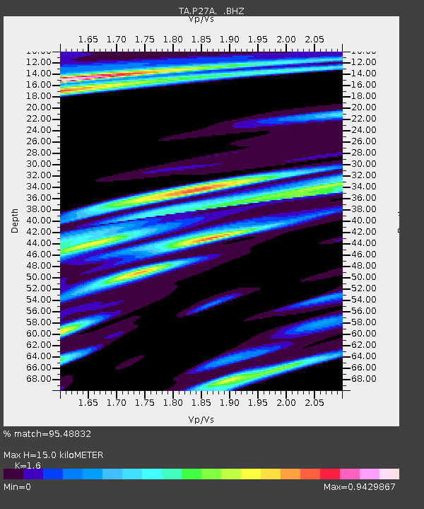
| Estimated Moho Depth: |
15.0 km |
| Estimated Crust Vp/Vs: |
1.60 |
| Assumed Crust Vp: |
6.242 km/s |
| Estimated Crust Vs: |
3.901 km/s |
| Estimated Crust Poisson's Ratio: |
0.18 |
|
| Radial Match: |
95.48832 % |
| Radial Bump: |
345 |
| Transverse Match: |
79.53494 % |
| Transverse Bump: |
400 |
| SOD ConfigId: |
319893 |
| Insert Time: |
2011-01-05 02:19:53.427 +0000 |
| GWidth: |
2.5 |
| Max Bumps: |
400 |
| Tol: |
0.001 |
|
Signal To Noise
| Channel | StoN | STA | LTA |
| TA:P27A: :BHZ:20100712T00:21:45.125Z | 36.9693 | 3.0718538E-6 | 8.3092026E-8 |
| TA:P27A: :BHN:20100712T00:21:45.125Z | 6.938025 | 1.1471611E-6 | 1.6534405E-7 |
| TA:P27A: :BHE:20100712T00:21:45.125Z | 7.7399135 | 9.912887E-7 | 1.2807492E-7 |
| Arrivals |
| Ps | 1.5 SECOND |
| PpPs | 6.0 SECOND |
| PsPs/PpSs | 7.5 SECOND |


