You are here: Home > Network List > TA - USArray Transportable Network (new EarthScope stations) Stations List
> Station 531A Rocksprings, TX, USA > Earthquake Result Viewer
531A Rocksprings, TX, USA - Earthquake Result Viewer
| Earthquake location: |
Northern Chile |
| Earthquake latitude/longitude: |
-22.1/-68.2 |
| Earthquake time(UTC): |
2010/07/12 (193) 00:11:21 GMT |
| Earthquake Depth: |
115 km |
| Earthquake Magnitude: |
6.1 MB, 6.3 MW, 6.2 MW |
| Earthquake Catalog/Contributor: |
WHDF/NEIC |
|
| Network: |
TA USArray Transportable Network (new EarthScope stations) |
| Station: |
531A Rocksprings, TX, USA |
| Lat/Lon: |
30.16 N/100.55 W |
| Elevation: |
661 m |
|
| Distance: |
60.6 deg |
| Az: |
327.881 deg |
| Baz: |
145.308 deg |
| Ray Param: |
0.061094567 |
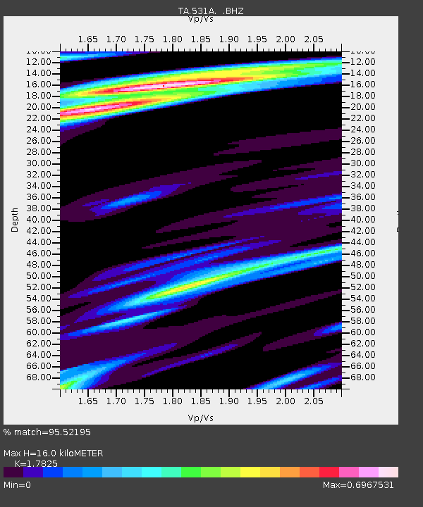
| Estimated Moho Depth: |
16.0 km |
| Estimated Crust Vp/Vs: |
1.78 |
| Assumed Crust Vp: |
6.38 km/s |
| Estimated Crust Vs: |
3.58 km/s |
| Estimated Crust Poisson's Ratio: |
0.27 |
|
| Radial Match: |
95.52195 % |
| Radial Bump: |
400 |
| Transverse Match: |
85.460846 % |
| Transverse Bump: |
400 |
| SOD ConfigId: |
319893 |
| Insert Time: |
2011-01-05 02:21:02.745 +0000 |
| GWidth: |
2.5 |
| Max Bumps: |
400 |
| Tol: |
0.001 |
|
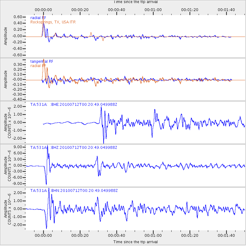
Signal To Noise
| Channel | StoN | STA | LTA |
| TA:531A: :BHZ:20100712T00:20:49.049988Z | 49.83461 | 4.1850194E-6 | 8.397817E-8 |
| TA:531A: :BHN:20100712T00:20:49.049988Z | 19.052631 | 1.2228562E-6 | 6.418306E-8 |
| TA:531A: :BHE:20100712T00:20:49.049988Z | 13.205699 | 1.0699108E-6 | 8.101887E-8 |
| Arrivals |
| Ps | 2.1 SECOND |
| PpPs | 6.7 SECOND |
| PsPs/PpSs | 8.7 SECOND |


