You are here: Home > Network List > TA - USArray Transportable Network (new EarthScope stations) Stations List
> Station 330A Mertzon, TX, USA > Earthquake Result Viewer
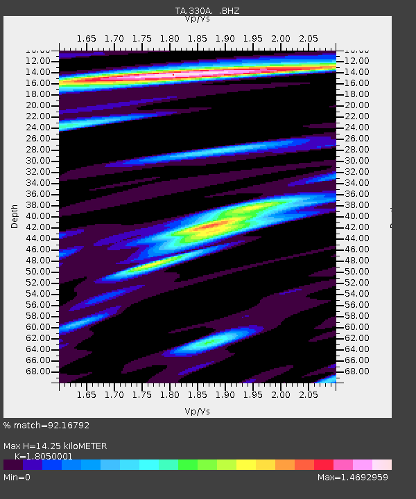
330A Mertzon, TX, USA - Earthquake Result Viewer
| Earthquake location: |
Northern Chile |
| Earthquake latitude/longitude: |
-22.1/-68.2 |
| Earthquake time(UTC): |
2010/07/12 (193) 00:11:21 GMT |
| Earthquake Depth: |
115 km |
| Earthquake Magnitude: |
6.1 MB, 6.3 MW, 6.2 MW |
| Earthquake Catalog/Contributor: |
WHDF/NEIC |
|
| Network: |
TA USArray Transportable Network (new EarthScope stations) |
| Station: |
330A Mertzon, TX, USA |
| Lat/Lon: |
31.41 N/101.18 W |
| Elevation: |
742 m |
|
| Distance: |
61.9 deg |
| Az: |
328.179 deg |
| Baz: |
145.131 deg |
| Ray Param: |
0.060240515 |
| Estimated Moho Depth: |
14.25 km |
| Estimated Crust Vp/Vs: |
1.81 |
| Assumed Crust Vp: |
6.38 km/s |
| Estimated Crust Vs: |
3.535 km/s |
| Estimated Crust Poisson's Ratio: |
0.28 |
|
| Radial Match: |
92.16792 % |
| Radial Bump: |
400 |
| Transverse Match: |
84.62545 % |
| Transverse Bump: |
400 |
| SOD ConfigId: |
319893 |
| Insert Time: |
2011-01-05 02:21:43.205 +0000 |
| GWidth: |
2.5 |
| Max Bumps: |
400 |
| Tol: |
0.001 |
|

Signal To Noise
| Channel | StoN | STA | LTA |
| TA:330A: :BHZ:20100712T00:20:57.950012Z | 29.229124 | 2.4335582E-6 | 8.3257994E-8 |
| TA:330A: :BHN:20100712T00:20:57.950012Z | 17.236002 | 7.8244176E-7 | 4.539578E-8 |
| TA:330A: :BHE:20100712T00:20:57.950012Z | 12.65392 | 5.896664E-7 | 4.6599503E-8 |
| Arrivals |
| Ps | 1.9 SECOND |
| PpPs | 6.0 SECOND |
| PsPs/PpSs | 7.9 SECOND |


