You are here: Home > Network List > TA - USArray Transportable Network (new EarthScope stations) Stations List
> Station Z32A Haskell, TX, USA > Earthquake Result Viewer
Z32A Haskell, TX, USA - Earthquake Result Viewer
| Earthquake location: |
Northern Chile |
| Earthquake latitude/longitude: |
-22.1/-68.2 |
| Earthquake time(UTC): |
2010/07/12 (193) 00:11:21 GMT |
| Earthquake Depth: |
115 km |
| Earthquake Magnitude: |
6.1 MB, 6.3 MW, 6.2 MW |
| Earthquake Catalog/Contributor: |
WHDF/NEIC |
|
| Network: |
TA USArray Transportable Network (new EarthScope stations) |
| Station: |
Z32A Haskell, TX, USA |
| Lat/Lon: |
33.31 N/99.48 W |
| Elevation: |
427 m |
|
| Distance: |
62.7 deg |
| Az: |
330.718 deg |
| Baz: |
147.215 deg |
| Ray Param: |
0.05974045 |
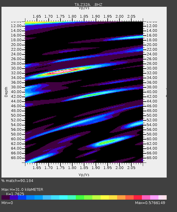
| Estimated Moho Depth: |
31.0 km |
| Estimated Crust Vp/Vs: |
1.76 |
| Assumed Crust Vp: |
6.426 km/s |
| Estimated Crust Vs: |
3.646 km/s |
| Estimated Crust Poisson's Ratio: |
0.26 |
|
| Radial Match: |
90.184 % |
| Radial Bump: |
400 |
| Transverse Match: |
71.187355 % |
| Transverse Bump: |
400 |
| SOD ConfigId: |
319893 |
| Insert Time: |
2011-01-05 02:22:07.407 +0000 |
| GWidth: |
2.5 |
| Max Bumps: |
400 |
| Tol: |
0.001 |
|
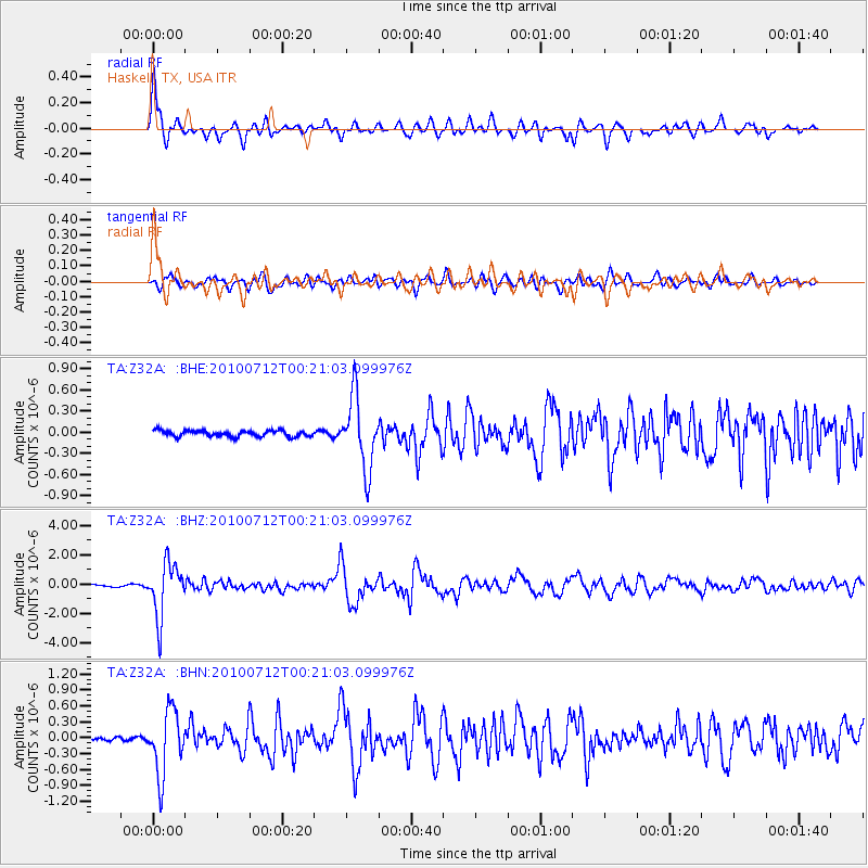
Signal To Noise
| Channel | StoN | STA | LTA |
| TA:Z32A: :BHZ:20100712T00:21:03.099976Z | 29.546925 | 1.8269438E-6 | 6.183194E-8 |
| TA:Z32A: :BHN:20100712T00:21:03.099976Z | 13.279902 | 6.07917E-7 | 4.577722E-8 |
| TA:Z32A: :BHE:20100712T00:21:03.099976Z | 11.814877 | 5.035415E-7 | 4.2619277E-8 |
| Arrivals |
| Ps | 3.8 SECOND |
| PpPs | 13 SECOND |
| PsPs/PpSs | 17 SECOND |


