You are here: Home > Network List > TA - USArray Transportable Network (new EarthScope stations) Stations List
> Station Y30A Stafford Cattle Company, Roaring Springs, TX, USA > Earthquake Result Viewer
Y30A Stafford Cattle Company, Roaring Springs, TX, USA - Earthquake Result Viewer

| Earthquake location: |
Northern Chile |
| Earthquake latitude/longitude: |
-22.1/-68.2 |
| Earthquake time(UTC): |
2010/07/12 (193) 00:11:21 GMT |
| Earthquake Depth: |
115 km |
| Earthquake Magnitude: |
6.1 MB, 6.3 MW, 6.2 MW |
| Earthquake Catalog/Contributor: |
WHDF/NEIC |
|
| Network: |
TA USArray Transportable Network (new EarthScope stations) |
| Station: |
Y30A Stafford Cattle Company, Roaring Springs, TX, USA |
| Lat/Lon: |
33.88 N/100.90 W |
| Elevation: |
812 m |
|
| Distance: |
63.8 deg |
| Az: |
329.959 deg |
| Baz: |
146.092 deg |
| Ray Param: |
0.05900768 |
| Estimated Moho Depth: |
52.5 km |
| Estimated Crust Vp/Vs: |
1.80 |
| Assumed Crust Vp: |
6.426 km/s |
| Estimated Crust Vs: |
3.575 km/s |
| Estimated Crust Poisson's Ratio: |
0.28 |
|
| Radial Match: |
88.74429 % |
| Radial Bump: |
400 |
| Transverse Match: |
80.17093 % |
| Transverse Bump: |
400 |
| SOD ConfigId: |
319893 |
| Insert Time: |
2011-01-05 02:22:19.456 +0000 |
| GWidth: |
2.5 |
| Max Bumps: |
400 |
| Tol: |
0.001 |
|
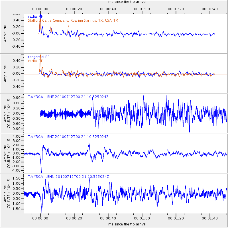
Signal To Noise
| Channel | StoN | STA | LTA |
| TA:Y30A: :BHZ:20100712T00:21:10.525024Z | 15.478707 | 1.6477187E-6 | 1.0645067E-7 |
| TA:Y30A: :BHN:20100712T00:21:10.525024Z | 4.3410616 | 7.352195E-7 | 1.6936399E-7 |
| TA:Y30A: :BHE:20100712T00:21:10.525024Z | 3.3890326 | 4.255888E-7 | 1.2557825E-7 |
| Arrivals |
| Ps | 6.8 SECOND |
| PpPs | 22 SECOND |
| PsPs/PpSs | 29 SECOND |


