You are here: Home > Network List > TX - Texas Seismological Network Stations List
> Station MB05 Klondike > Earthquake Result Viewer
MB05 Klondike - Earthquake Result Viewer
| Earthquake location: |
South Of Fiji Islands |
| Earthquake latitude/longitude: |
-24.6/-176.0 |
| Earthquake time(UTC): |
2023/08/16 (228) 16:00:22 GMT |
| Earthquake Depth: |
29 km |
| Earthquake Magnitude: |
5.5 Mww |
| Earthquake Catalog/Contributor: |
NEIC PDE/us |
|
| Network: |
TX Texas Seismological Network |
| Station: |
MB05 Klondike |
| Lat/Lon: |
32.63 N/101.86 W |
| Elevation: |
882 m |
|
| Distance: |
90.7 deg |
| Az: |
54.273 deg |
| Baz: |
241.139 deg |
| Ray Param: |
0.041680384 |
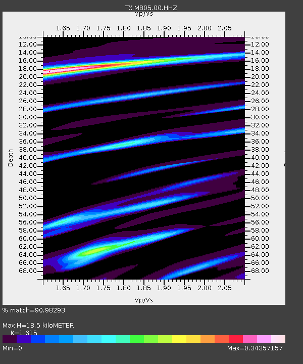
| Estimated Moho Depth: |
18.5 km |
| Estimated Crust Vp/Vs: |
1.62 |
| Assumed Crust Vp: |
6.426 km/s |
| Estimated Crust Vs: |
3.979 km/s |
| Estimated Crust Poisson's Ratio: |
0.19 |
|
| Radial Match: |
90.98293 % |
| Radial Bump: |
241 |
| Transverse Match: |
74.42228 % |
| Transverse Bump: |
400 |
| SOD ConfigId: |
31937991 |
| Insert Time: |
2023-09-03 04:09:01.090 +0000 |
| GWidth: |
2.5 |
| Max Bumps: |
400 |
| Tol: |
0.001 |
|

Signal To Noise
| Channel | StoN | STA | LTA |
| TX:MB05:00:HHZ:20230816T16:12:51.389012Z | 1.6872603 | 1.1462694E-6 | 6.7936725E-7 |
| TX:MB05:00:HHN:20230816T16:12:51.389012Z | 0.85356903 | 3.3854667E-7 | 3.966248E-7 |
| TX:MB05:00:HHE:20230816T16:12:51.389012Z | 2.305434 | 8.430984E-7 | 3.6570052E-7 |
| Arrivals |
| Ps | 1.8 SECOND |
| PpPs | 7.4 SECOND |
| PsPs/PpSs | 9.2 SECOND |


