You are here: Home > Network List > US - United States National Seismic Network Stations List
> Station TPNV Topopah Spring, Nevada, USA > Earthquake Result Viewer
TPNV Topopah Spring, Nevada, USA - Earthquake Result Viewer
| Earthquake location: |
South Of Fiji Islands |
| Earthquake latitude/longitude: |
-24.6/-176.0 |
| Earthquake time(UTC): |
2023/08/16 (228) 16:00:22 GMT |
| Earthquake Depth: |
29 km |
| Earthquake Magnitude: |
5.5 Mww |
| Earthquake Catalog/Contributor: |
NEIC PDE/us |
|
| Network: |
US United States National Seismic Network |
| Station: |
TPNV Topopah Spring, Nevada, USA |
| Lat/Lon: |
36.95 N/116.25 W |
| Elevation: |
1600 m |
|
| Distance: |
83.1 deg |
| Az: |
44.194 deg |
| Baz: |
232.386 deg |
| Ray Param: |
0.046371073 |
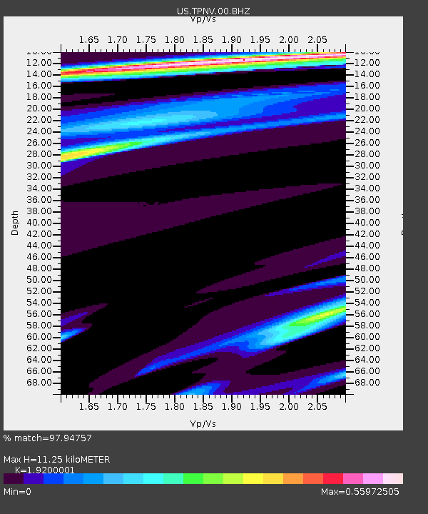
| Estimated Moho Depth: |
11.25 km |
| Estimated Crust Vp/Vs: |
1.92 |
| Assumed Crust Vp: |
6.279 km/s |
| Estimated Crust Vs: |
3.27 km/s |
| Estimated Crust Poisson's Ratio: |
0.31 |
|
| Radial Match: |
97.94757 % |
| Radial Bump: |
189 |
| Transverse Match: |
95.85083 % |
| Transverse Bump: |
322 |
| SOD ConfigId: |
31937991 |
| Insert Time: |
2023-09-03 04:10:12.900 +0000 |
| GWidth: |
2.5 |
| Max Bumps: |
400 |
| Tol: |
0.001 |
|

Signal To Noise
| Channel | StoN | STA | LTA |
| US:TPNV:00:BHZ:20230816T16:12:14.673985Z | 2.1559668 | 6.4455804E-7 | 2.9896475E-7 |
| US:TPNV:00:BH1:20230816T16:12:14.673985Z | 2.2698169 | 7.3179206E-7 | 3.2240138E-7 |
| US:TPNV:00:BH2:20230816T16:12:14.673985Z | 3.7047176 | 5.2713784E-7 | 1.4228826E-7 |
| Arrivals |
| Ps | 1.7 SECOND |
| PpPs | 5.1 SECOND |
| PsPs/PpSs | 6.8 SECOND |


