You are here: Home > Network List > TA - USArray Transportable Network (new EarthScope stations) Stations List
> Station V27A Dan Oppilter Farms, Dalhart, TX, USA > Earthquake Result Viewer
V27A Dan Oppilter Farms, Dalhart, TX, USA - Earthquake Result Viewer
| Earthquake location: |
Northern Chile |
| Earthquake latitude/longitude: |
-22.1/-68.2 |
| Earthquake time(UTC): |
2010/07/12 (193) 00:11:21 GMT |
| Earthquake Depth: |
115 km |
| Earthquake Magnitude: |
6.1 MB, 6.3 MW, 6.2 MW |
| Earthquake Catalog/Contributor: |
WHDF/NEIC |
|
| Network: |
TA USArray Transportable Network (new EarthScope stations) |
| Station: |
V27A Dan Oppilter Farms, Dalhart, TX, USA |
| Lat/Lon: |
35.76 N/102.84 W |
| Elevation: |
1228 m |
|
| Distance: |
66.3 deg |
| Az: |
329.682 deg |
| Baz: |
144.873 deg |
| Ray Param: |
0.05741805 |
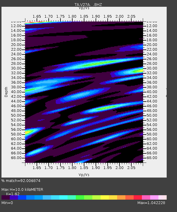
| Estimated Moho Depth: |
10.0 km |
| Estimated Crust Vp/Vs: |
1.62 |
| Assumed Crust Vp: |
6.242 km/s |
| Estimated Crust Vs: |
3.853 km/s |
| Estimated Crust Poisson's Ratio: |
0.19 |
|
| Radial Match: |
92.006874 % |
| Radial Bump: |
400 |
| Transverse Match: |
81.46845 % |
| Transverse Bump: |
400 |
| SOD ConfigId: |
319893 |
| Insert Time: |
2011-01-05 02:23:53.190 +0000 |
| GWidth: |
2.5 |
| Max Bumps: |
400 |
| Tol: |
0.001 |
|

Signal To Noise
| Channel | StoN | STA | LTA |
| TA:V27A: :BHZ:20100712T00:21:26.299988Z | 46.4781 | 2.5227391E-6 | 5.4278022E-8 |
| TA:V27A: :BHN:20100712T00:21:26.299988Z | 11.350712 | 1.0287265E-6 | 9.063101E-8 |
| TA:V27A: :BHE:20100712T00:21:26.299988Z | 8.230844 | 7.5758027E-7 | 9.204163E-8 |
| Arrivals |
| Ps | 1.0 SECOND |
| PpPs | 4.0 SECOND |
| PsPs/PpSs | 5.1 SECOND |


