You are here: Home > Network List > TA - USArray Transportable Network (new EarthScope stations) Stations List
> Station R29A Marienthal, KS, USA > Earthquake Result Viewer
R29A Marienthal, KS, USA - Earthquake Result Viewer

| Earthquake location: |
Northern Chile |
| Earthquake latitude/longitude: |
-22.1/-68.2 |
| Earthquake time(UTC): |
2010/07/12 (193) 00:11:21 GMT |
| Earthquake Depth: |
115 km |
| Earthquake Magnitude: |
6.1 MB, 6.3 MW, 6.2 MW |
| Earthquake Catalog/Contributor: |
WHDF/NEIC |
|
| Network: |
TA USArray Transportable Network (new EarthScope stations) |
| Station: |
R29A Marienthal, KS, USA |
| Lat/Lon: |
38.42 N/101.14 W |
| Elevation: |
957 m |
|
| Distance: |
67.7 deg |
| Az: |
332.524 deg |
| Baz: |
147.004 deg |
| Ray Param: |
0.056477603 |
| Estimated Moho Depth: |
18.0 km |
| Estimated Crust Vp/Vs: |
2.06 |
| Assumed Crust Vp: |
6.483 km/s |
| Estimated Crust Vs: |
3.143 km/s |
| Estimated Crust Poisson's Ratio: |
0.35 |
|
| Radial Match: |
97.13981 % |
| Radial Bump: |
276 |
| Transverse Match: |
88.14044 % |
| Transverse Bump: |
400 |
| SOD ConfigId: |
319893 |
| Insert Time: |
2011-01-05 02:24:29.276 +0000 |
| GWidth: |
2.5 |
| Max Bumps: |
400 |
| Tol: |
0.001 |
|
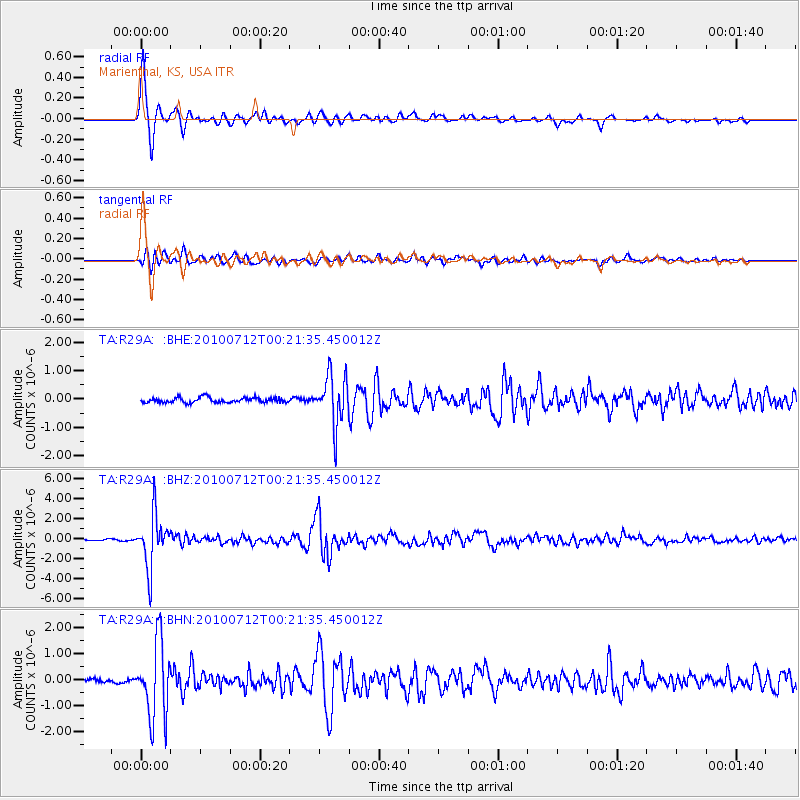
Signal To Noise
| Channel | StoN | STA | LTA |
| TA:R29A: :BHZ:20100712T00:21:35.450012Z | 37.096878 | 2.6567757E-6 | 7.161723E-8 |
| TA:R29A: :BHN:20100712T00:21:35.450012Z | 22.144156 | 1.4538099E-6 | 6.565208E-8 |
| TA:R29A: :BHE:20100712T00:21:35.450012Z | 9.767521 | 8.611413E-7 | 8.816375E-8 |
| Arrivals |
| Ps | 3.1 SECOND |
| PpPs | 8.2 SECOND |
| PsPs/PpSs | 11 SECOND |


