You are here: Home > Network List > TA - USArray Transportable Network (new EarthScope stations) Stations List
> Station P29A Atwood, KS, USA > Earthquake Result Viewer
P29A Atwood, KS, USA - Earthquake Result Viewer
| Earthquake location: |
Northern Chile |
| Earthquake latitude/longitude: |
-22.1/-68.2 |
| Earthquake time(UTC): |
2010/07/12 (193) 00:11:21 GMT |
| Earthquake Depth: |
115 km |
| Earthquake Magnitude: |
6.1 MB, 6.3 MW, 6.2 MW |
| Earthquake Catalog/Contributor: |
WHDF/NEIC |
|
| Network: |
TA USArray Transportable Network (new EarthScope stations) |
| Station: |
P29A Atwood, KS, USA |
| Lat/Lon: |
39.60 N/100.93 W |
| Elevation: |
929 m |
|
| Distance: |
68.6 deg |
| Az: |
333.356 deg |
| Baz: |
147.443 deg |
| Ray Param: |
0.055891544 |
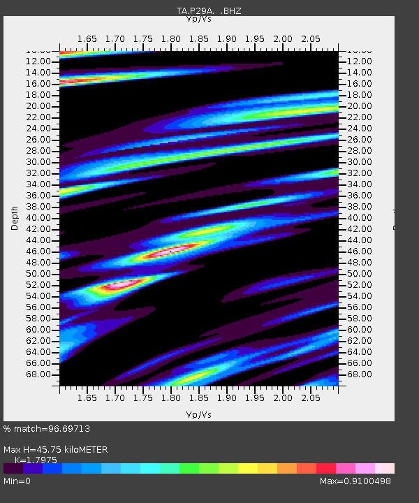
| Estimated Moho Depth: |
45.75 km |
| Estimated Crust Vp/Vs: |
1.80 |
| Assumed Crust Vp: |
6.483 km/s |
| Estimated Crust Vs: |
3.606 km/s |
| Estimated Crust Poisson's Ratio: |
0.28 |
|
| Radial Match: |
96.69713 % |
| Radial Bump: |
274 |
| Transverse Match: |
89.869896 % |
| Transverse Bump: |
378 |
| SOD ConfigId: |
319893 |
| Insert Time: |
2011-01-05 02:25:03.820 +0000 |
| GWidth: |
2.5 |
| Max Bumps: |
400 |
| Tol: |
0.001 |
|
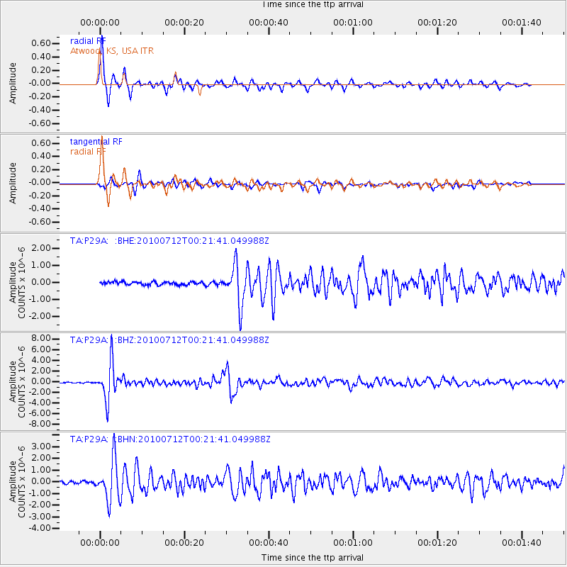
Signal To Noise
| Channel | StoN | STA | LTA |
| TA:P29A: :BHZ:20100712T00:21:41.049988Z | 56.61812 | 3.4386424E-6 | 6.073395E-8 |
| TA:P29A: :BHN:20100712T00:21:41.049988Z | 21.888102 | 1.7594779E-6 | 8.038513E-8 |
| TA:P29A: :BHE:20100712T00:21:41.049988Z | 13.295196 | 1.1621471E-6 | 8.741106E-8 |
| Arrivals |
| Ps | 5.8 SECOND |
| PpPs | 19 SECOND |
| PsPs/PpSs | 25 SECOND |


