You are here: Home > Network List > TA - USArray Transportable Network (new EarthScope stations) Stations List
> Station P31A Stockton, KS, USA > Earthquake Result Viewer
P31A Stockton, KS, USA - Earthquake Result Viewer
| Earthquake location: |
Northern Chile |
| Earthquake latitude/longitude: |
-22.1/-68.2 |
| Earthquake time(UTC): |
2010/07/12 (193) 00:11:21 GMT |
| Earthquake Depth: |
115 km |
| Earthquake Magnitude: |
6.1 MB, 6.3 MW, 6.2 MW |
| Earthquake Catalog/Contributor: |
WHDF/NEIC |
|
| Network: |
TA USArray Transportable Network (new EarthScope stations) |
| Station: |
P31A Stockton, KS, USA |
| Lat/Lon: |
39.52 N/99.38 W |
| Elevation: |
665 m |
|
| Distance: |
67.9 deg |
| Az: |
334.408 deg |
| Baz: |
148.818 deg |
| Ray Param: |
0.05634824 |
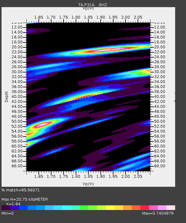
| Estimated Moho Depth: |
20.75 km |
| Estimated Crust Vp/Vs: |
1.94 |
| Assumed Crust Vp: |
6.483 km/s |
| Estimated Crust Vs: |
3.342 km/s |
| Estimated Crust Poisson's Ratio: |
0.32 |
|
| Radial Match: |
95.96071 % |
| Radial Bump: |
337 |
| Transverse Match: |
83.2124 % |
| Transverse Bump: |
400 |
| SOD ConfigId: |
319893 |
| Insert Time: |
2011-01-05 02:25:35.190 +0000 |
| GWidth: |
2.5 |
| Max Bumps: |
400 |
| Tol: |
0.001 |
|

Signal To Noise
| Channel | StoN | STA | LTA |
| TA:P31A: :BHZ:20100712T00:21:36.674988Z | 41.298157 | 3.2743144E-6 | 7.928476E-8 |
| TA:P31A: :BHN:20100712T00:21:36.674988Z | 13.853917 | 1.4356449E-6 | 1.0362736E-7 |
| TA:P31A: :BHE:20100712T00:21:36.674988Z | 10.358532 | 1.155566E-6 | 1.1155693E-7 |
| Arrivals |
| Ps | 3.1 SECOND |
| PpPs | 9.1 SECOND |
| PsPs/PpSs | 12 SECOND |


