You are here: Home > Network List > IU - Global Seismograph Network (GSN - IRIS/USGS) Stations List
> Station MAKZ Makanchi, Kazakhstan > Earthquake Result Viewer
MAKZ Makanchi, Kazakhstan - Earthquake Result Viewer
*The percent match for this event was below the threshold and hence no stack was calculated.
| Earthquake location: |
Komandorskiye Ostrova Region |
| Earthquake latitude/longitude: |
55.3/164.4 |
| Earthquake time(UTC): |
2018/12/21 (355) 18:19:36 GMT |
| Earthquake Depth: |
16 km |
| Earthquake Magnitude: |
5.6 Mww |
| Earthquake Catalog/Contributor: |
NEIC PDE/us |
|
| Network: |
IU Global Seismograph Network (GSN - IRIS/USGS) |
| Station: |
MAKZ Makanchi, Kazakhstan |
| Lat/Lon: |
46.81 N/81.98 E |
| Elevation: |
600 m |
|
| Distance: |
49.6 deg |
| Az: |
296.669 deg |
| Baz: |
48.115 deg |
| Ray Param: |
$rayparam |
*The percent match for this event was below the threshold and hence was not used in the summary stack. |
|
| Radial Match: |
55.82725 % |
| Radial Bump: |
400 |
| Transverse Match: |
58.99869 % |
| Transverse Bump: |
400 |
| SOD ConfigId: |
3201911 |
| Insert Time: |
2019-01-04 18:30:50.938 +0000 |
| GWidth: |
2.5 |
| Max Bumps: |
400 |
| Tol: |
0.001 |
|
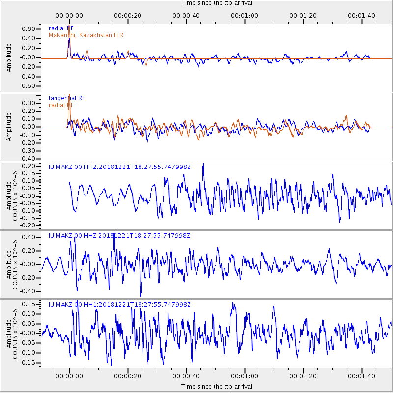
Signal To Noise
| Channel | StoN | STA | LTA |
| IU:MAKZ:00:HHZ:20181221T18:27:55.747998Z | 2.637979 | 2.0065741E-7 | 7.606483E-8 |
| IU:MAKZ:00:HH1:20181221T18:27:55.747998Z | 2.365531 | 7.785291E-8 | 3.2911387E-8 |
| IU:MAKZ:00:HH2:20181221T18:27:55.747998Z | 1.8690432 | 8.984589E-8 | 4.8070525E-8 |
| Arrivals |
| Ps | |
| PpPs | |
| PsPs/PpSs | |


