You are here: Home > Network List > TA - USArray Transportable Network (new EarthScope stations) Stations List
> Station I26A New Underwood, SD, USA > Earthquake Result Viewer
I26A New Underwood, SD, USA - Earthquake Result Viewer
| Earthquake location: |
Northern Chile |
| Earthquake latitude/longitude: |
-22.1/-68.2 |
| Earthquake time(UTC): |
2010/07/12 (193) 00:11:21 GMT |
| Earthquake Depth: |
115 km |
| Earthquake Magnitude: |
6.1 MB, 6.3 MW, 6.2 MW |
| Earthquake Catalog/Contributor: |
WHDF/NEIC |
|
| Network: |
TA USArray Transportable Network (new EarthScope stations) |
| Station: |
I26A New Underwood, SD, USA |
| Lat/Lon: |
44.03 N/102.86 W |
| Elevation: |
971 m |
|
| Distance: |
73.1 deg |
| Az: |
334.626 deg |
| Baz: |
146.578 deg |
| Ray Param: |
0.052939136 |
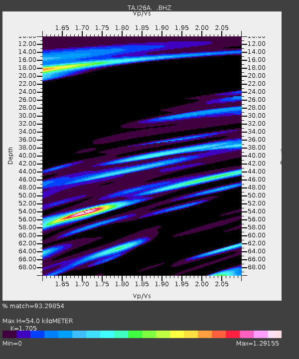
| Estimated Moho Depth: |
54.0 km |
| Estimated Crust Vp/Vs: |
1.71 |
| Assumed Crust Vp: |
6.242 km/s |
| Estimated Crust Vs: |
3.661 km/s |
| Estimated Crust Poisson's Ratio: |
0.24 |
|
| Radial Match: |
93.29854 % |
| Radial Bump: |
400 |
| Transverse Match: |
83.437996 % |
| Transverse Bump: |
400 |
| SOD ConfigId: |
319893 |
| Insert Time: |
2011-01-05 02:27:17.252 +0000 |
| GWidth: |
2.5 |
| Max Bumps: |
400 |
| Tol: |
0.001 |
|

Signal To Noise
| Channel | StoN | STA | LTA |
| TA:I26A: :BHZ:20100712T00:22:08.150024Z | 32.543743 | 4.210189E-6 | 1.2937016E-7 |
| TA:I26A: :BHN:20100712T00:22:08.150024Z | 5.9219904 | 1.2559531E-6 | 2.1208294E-7 |
| TA:I26A: :BHE:20100712T00:22:08.150024Z | 8.113887 | 1.2212626E-6 | 1.505151E-7 |
| Arrivals |
| Ps | 6.3 SECOND |
| PpPs | 23 SECOND |
| PsPs/PpSs | 29 SECOND |


