You are here: Home > Network List > TA - USArray Transportable Network (new EarthScope stations) Stations List
> Station J27A Elkhorn Farm, Martin, SD, USA > Earthquake Result Viewer
J27A Elkhorn Farm, Martin, SD, USA - Earthquake Result Viewer
| Earthquake location: |
Northern Chile |
| Earthquake latitude/longitude: |
-22.1/-68.2 |
| Earthquake time(UTC): |
2010/07/12 (193) 00:11:21 GMT |
| Earthquake Depth: |
115 km |
| Earthquake Magnitude: |
6.1 MB, 6.3 MW, 6.2 MW |
| Earthquake Catalog/Contributor: |
WHDF/NEIC |
|
| Network: |
TA USArray Transportable Network (new EarthScope stations) |
| Station: |
J27A Elkhorn Farm, Martin, SD, USA |
| Lat/Lon: |
43.25 N/102.01 W |
| Elevation: |
1081 m |
|
| Distance: |
72.1 deg |
| Az: |
334.724 deg |
| Baz: |
147.194 deg |
| Ray Param: |
0.05358534 |
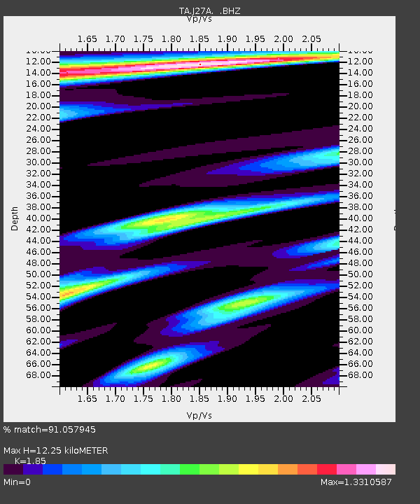
| Estimated Moho Depth: |
12.25 km |
| Estimated Crust Vp/Vs: |
1.85 |
| Assumed Crust Vp: |
6.483 km/s |
| Estimated Crust Vs: |
3.504 km/s |
| Estimated Crust Poisson's Ratio: |
0.29 |
|
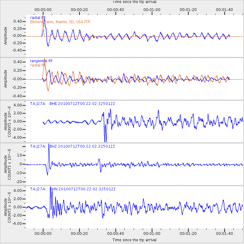
| Radial Match: |
91.057945 % |
| Radial Bump: |
400 |
| Transverse Match: |
88.90311 % |
| Transverse Bump: |
400 |
| SOD ConfigId: |
319893 |
| Insert Time: |
2011-01-05 02:28:53.455 +0000 |
| GWidth: |
2.5 |
| Max Bumps: |
400 |
| Tol: |
0.001 |
|
Signal To Noise
| Channel | StoN | STA | LTA |
| TA:J27A: :BHZ:20100712T00:22:02.325012Z | 76.345474 | 6.9225202E-6 | 9.067362E-8 |
| TA:J27A: :BHN:20100712T00:22:02.325012Z | 11.743425 | 1.6485724E-6 | 1.4038258E-7 |
| TA:J27A: :BHE:20100712T00:22:02.325012Z | 7.91147 | 1.7584883E-6 | 2.2227074E-7 |
| Arrivals |
| Ps | 1.7 SECOND |
| PpPs | 5.2 SECOND |
| PsPs/PpSs | 6.9 SECOND |


