You are here: Home > Network List > G - GEOSCOPE Stations List
> Station MPG Montagne des Peres, French Guyana > Earthquake Result Viewer
MPG Montagne des Peres, French Guyana - Earthquake Result Viewer

| Earthquake location: |
Santiago Del Estero Prov., Arg. |
| Earthquake latitude/longitude: |
-26.9/-63.3 |
| Earthquake time(UTC): |
2023/08/23 (235) 14:22:43 GMT |
| Earthquake Depth: |
569 km |
| Earthquake Magnitude: |
6.2 mww |
| Earthquake Catalog/Contributor: |
NEIC PDE/us |
|
| Network: |
G GEOSCOPE |
| Station: |
MPG Montagne des Peres, French Guyana |
| Lat/Lon: |
5.11 N/52.64 W |
| Elevation: |
147 m |
|
| Distance: |
33.5 deg |
| Az: |
19.577 deg |
| Baz: |
197.478 deg |
| Ray Param: |
0.07545989 |
| Estimated Moho Depth: |
41.0 km |
| Estimated Crust Vp/Vs: |
1.70 |
| Assumed Crust Vp: |
6.472 km/s |
| Estimated Crust Vs: |
3.801 km/s |
| Estimated Crust Poisson's Ratio: |
0.24 |
|
| Radial Match: |
90.99602 % |
| Radial Bump: |
292 |
| Transverse Match: |
76.63579 % |
| Transverse Bump: |
400 |
| SOD ConfigId: |
31937991 |
| Insert Time: |
2023-09-06 14:32:50.676 +0000 |
| GWidth: |
2.5 |
| Max Bumps: |
400 |
| Tol: |
0.001 |
|
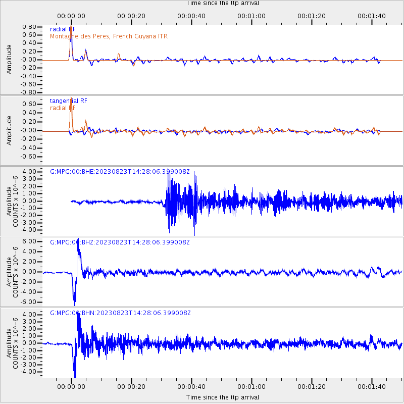
Signal To Noise
| Channel | StoN | STA | LTA |
| G:MPG:00:BHZ:20230823T14:28:06.399008Z | 18.55404 | 2.8864672E-6 | 1.5557082E-7 |
| G:MPG:00:BHN:20230823T14:28:06.399008Z | 18.892666 | 1.9758652E-6 | 1.0458372E-7 |
| G:MPG:00:BHE:20230823T14:28:06.399008Z | 16.561518 | 1.7275083E-6 | 1.0430857E-7 |
| Arrivals |
| Ps | 4.8 SECOND |
| PpPs | 16 SECOND |
| PsPs/PpSs | 21 SECOND |


