You are here: Home > Network List > TA - USArray Transportable Network (new EarthScope stations) Stations List
> Station J29A Okreek, SD, USA > Earthquake Result Viewer
J29A Okreek, SD, USA - Earthquake Result Viewer

| Earthquake location: |
Northern Chile |
| Earthquake latitude/longitude: |
-22.1/-68.2 |
| Earthquake time(UTC): |
2010/07/12 (193) 00:11:21 GMT |
| Earthquake Depth: |
115 km |
| Earthquake Magnitude: |
6.1 MB, 6.3 MW, 6.2 MW |
| Earthquake Catalog/Contributor: |
WHDF/NEIC |
|
| Network: |
TA USArray Transportable Network (new EarthScope stations) |
| Station: |
J29A Okreek, SD, USA |
| Lat/Lon: |
43.41 N/100.33 W |
| Elevation: |
644 m |
|
| Distance: |
71.6 deg |
| Az: |
335.904 deg |
| Baz: |
148.711 deg |
| Ray Param: |
0.05392976 |
| Estimated Moho Depth: |
10.0 km |
| Estimated Crust Vp/Vs: |
1.60 |
| Assumed Crust Vp: |
6.483 km/s |
| Estimated Crust Vs: |
4.052 km/s |
| Estimated Crust Poisson's Ratio: |
0.18 |
|
| Radial Match: |
93.14663 % |
| Radial Bump: |
400 |
| Transverse Match: |
83.10061 % |
| Transverse Bump: |
400 |
| SOD ConfigId: |
319893 |
| Insert Time: |
2011-01-05 02:31:37.252 +0000 |
| GWidth: |
2.5 |
| Max Bumps: |
400 |
| Tol: |
0.001 |
|
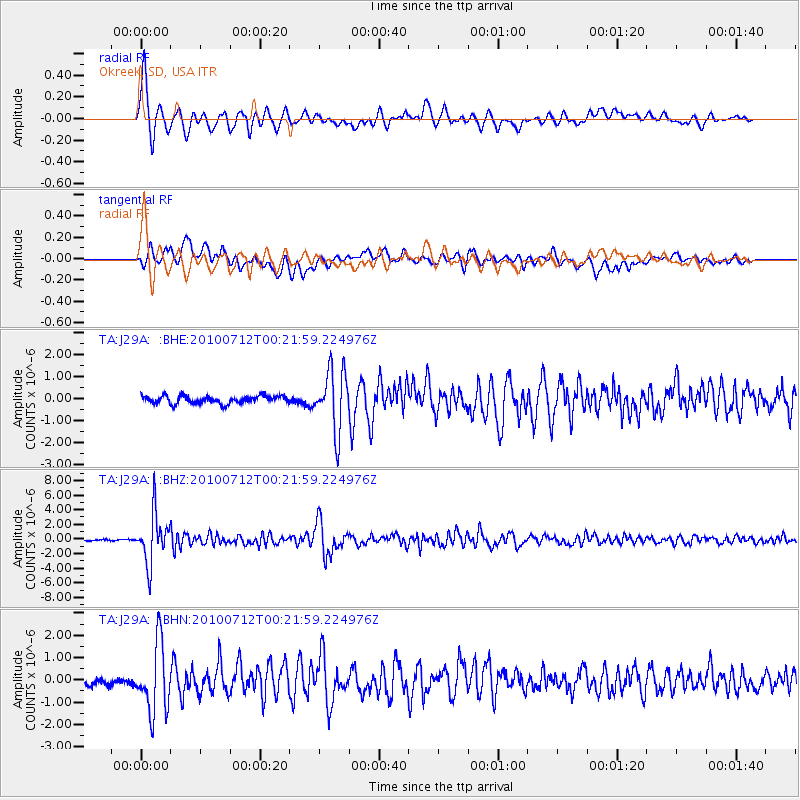
Signal To Noise
| Channel | StoN | STA | LTA |
| TA:J29A: :BHZ:20100712T00:21:59.224976Z | 37.959938 | 3.392595E-6 | 8.937304E-8 |
| TA:J29A: :BHN:20100712T00:21:59.224976Z | 7.9021235 | 1.5354448E-6 | 1.9430786E-7 |
| TA:J29A: :BHE:20100712T00:21:59.224976Z | 7.9467278 | 1.3605253E-6 | 1.7120571E-7 |
| Arrivals |
| Ps | 1.0 SECOND |
| PpPs | 3.9 SECOND |
| PsPs/PpSs | 4.8 SECOND |


