You are here: Home > Network List > TA - USArray Transportable Network (new EarthScope stations) Stations List
> Station V33A Lossen Ranch, Watonga, OK, USA > Earthquake Result Viewer
V33A Lossen Ranch, Watonga, OK, USA - Earthquake Result Viewer
| Earthquake location: |
Northern Chile |
| Earthquake latitude/longitude: |
-22.1/-68.2 |
| Earthquake time(UTC): |
2010/07/12 (193) 00:11:21 GMT |
| Earthquake Depth: |
115 km |
| Earthquake Magnitude: |
6.1 MB, 6.3 MW, 6.2 MW |
| Earthquake Catalog/Contributor: |
WHDF/NEIC |
|
| Network: |
TA USArray Transportable Network (new EarthScope stations) |
| Station: |
V33A Lossen Ranch, Watonga, OK, USA |
| Lat/Lon: |
35.82 N/98.29 W |
| Elevation: |
420 m |
|
| Distance: |
64.3 deg |
| Az: |
333.133 deg |
| Baz: |
148.967 deg |
| Ray Param: |
0.058700524 |
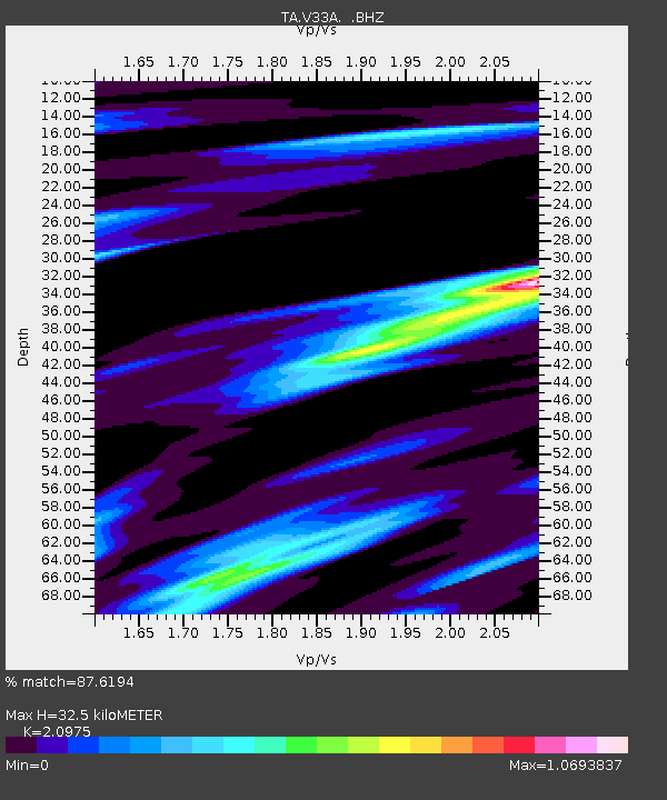
| Estimated Moho Depth: |
32.5 km |
| Estimated Crust Vp/Vs: |
2.10 |
| Assumed Crust Vp: |
6.315 km/s |
| Estimated Crust Vs: |
3.011 km/s |
| Estimated Crust Poisson's Ratio: |
0.35 |
|
| Radial Match: |
87.6194 % |
| Radial Bump: |
400 |
| Transverse Match: |
76.30513 % |
| Transverse Bump: |
400 |
| SOD ConfigId: |
319893 |
| Insert Time: |
2011-01-05 02:33:58.842 +0000 |
| GWidth: |
2.5 |
| Max Bumps: |
400 |
| Tol: |
0.001 |
|
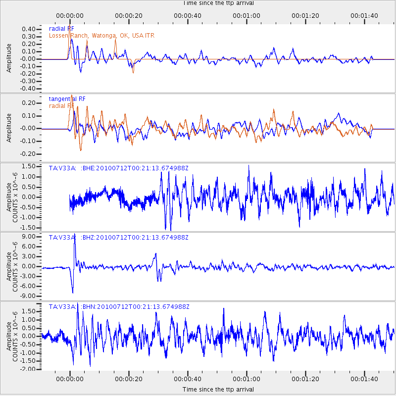
Signal To Noise
| Channel | StoN | STA | LTA |
| TA:V33A: :BHZ:20100712T00:21:13.674988Z | 15.47251 | 3.4364714E-6 | 2.2210175E-7 |
| TA:V33A: :BHN:20100712T00:21:13.674988Z | 4.6586833 | 8.172411E-7 | 1.754232E-7 |
| TA:V33A: :BHE:20100712T00:21:13.674988Z | 2.7334745 | 7.4147647E-7 | 2.7125787E-7 |
| Arrivals |
| Ps | 5.8 SECOND |
| PpPs | 15 SECOND |
| PsPs/PpSs | 21 SECOND |


