You are here: Home > Network List > TA - USArray Transportable Network (new EarthScope stations) Stations List
> Station V34A Guthrie, OK, USA > Earthquake Result Viewer
V34A Guthrie, OK, USA - Earthquake Result Viewer
| Earthquake location: |
Northern Chile |
| Earthquake latitude/longitude: |
-22.1/-68.2 |
| Earthquake time(UTC): |
2010/07/12 (193) 00:11:21 GMT |
| Earthquake Depth: |
115 km |
| Earthquake Magnitude: |
6.1 MB, 6.3 MW, 6.2 MW |
| Earthquake Catalog/Contributor: |
WHDF/NEIC |
|
| Network: |
TA USArray Transportable Network (new EarthScope stations) |
| Station: |
V34A Guthrie, OK, USA |
| Lat/Lon: |
35.83 N/97.52 W |
| Elevation: |
329 m |
|
| Distance: |
64.0 deg |
| Az: |
333.737 deg |
| Baz: |
149.678 deg |
| Ray Param: |
0.058895707 |
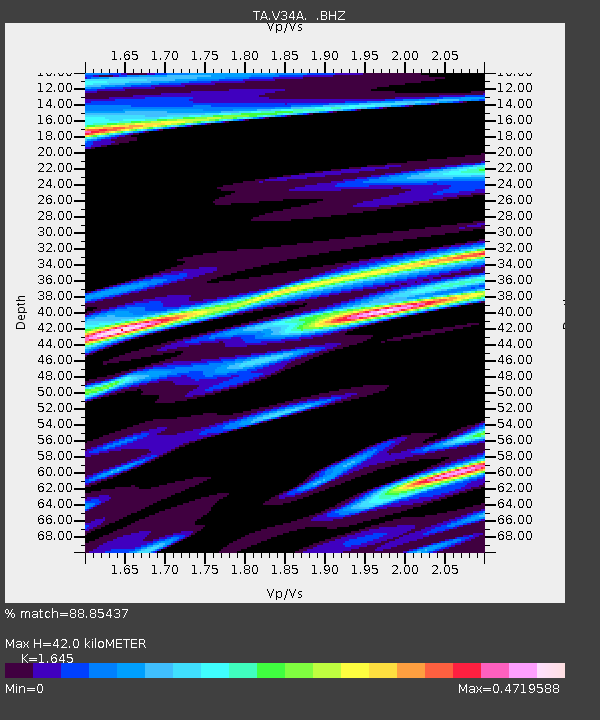
| Estimated Moho Depth: |
42.0 km |
| Estimated Crust Vp/Vs: |
1.64 |
| Assumed Crust Vp: |
6.426 km/s |
| Estimated Crust Vs: |
3.906 km/s |
| Estimated Crust Poisson's Ratio: |
0.21 |
|
| Radial Match: |
88.85437 % |
| Radial Bump: |
400 |
| Transverse Match: |
66.60284 % |
| Transverse Bump: |
400 |
| SOD ConfigId: |
319893 |
| Insert Time: |
2011-01-05 02:34:02.655 +0000 |
| GWidth: |
2.5 |
| Max Bumps: |
400 |
| Tol: |
0.001 |
|
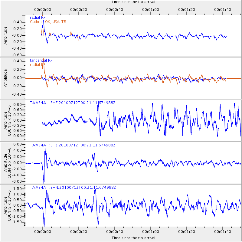
Signal To Noise
| Channel | StoN | STA | LTA |
| TA:V34A: :BHZ:20100712T00:21:11.674988Z | 30.887457 | 2.5474424E-6 | 8.247498E-8 |
| TA:V34A: :BHN:20100712T00:21:11.674988Z | 5.5694585 | 7.971531E-7 | 1.4312937E-7 |
| TA:V34A: :BHE:20100712T00:21:11.674988Z | 3.5015144 | 5.068646E-7 | 1.4475582E-7 |
| Arrivals |
| Ps | 4.4 SECOND |
| PpPs | 17 SECOND |
| PsPs/PpSs | 21 SECOND |


