You are here: Home > Network List > TA - USArray Transportable Network (new EarthScope stations) Stations List
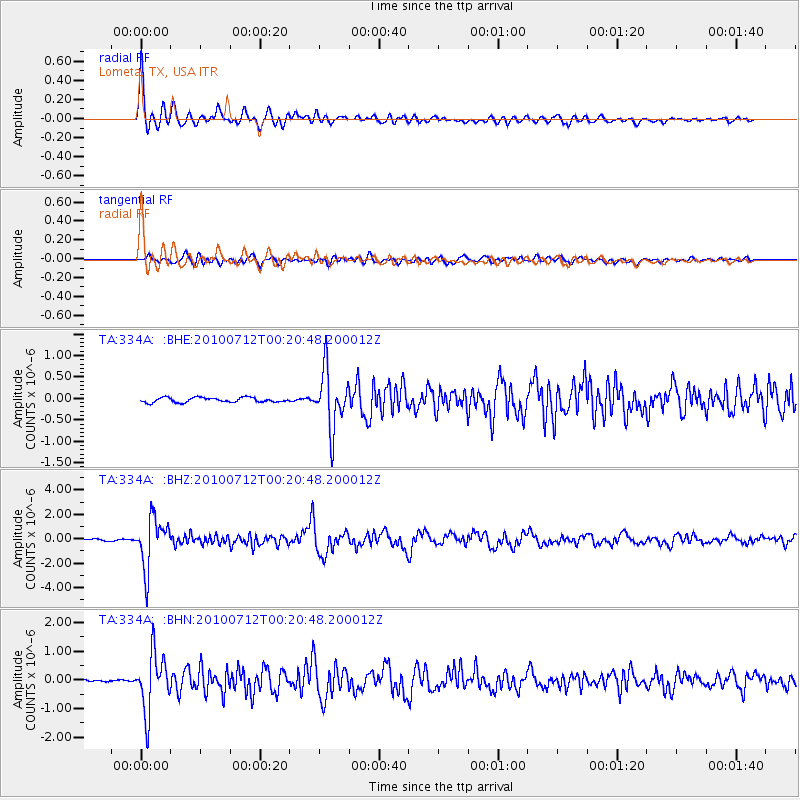
> Station 334A Lometa, TX, USA > Earthquake Result Viewer
334A Lometa, TX, USA - Earthquake Result Viewer
| Earthquake location: |
Northern Chile |
| Earthquake latitude/longitude: |
-22.1/-68.2 |
| Earthquake time(UTC): |
2010/07/12 (193) 00:11:21 GMT |
| Earthquake Depth: |
115 km |
| Earthquake Magnitude: |
6.1 MB, 6.3 MW, 6.2 MW |
| Earthquake Catalog/Contributor: |
WHDF/NEIC |
|
| Network: |
TA USArray Transportable Network (new EarthScope stations) |
| Station: |
334A Lometa, TX, USA |
| Lat/Lon: |
31.33 N/98.24 W |
| Elevation: |
389 m |
|
| Distance: |
60.5 deg |
| Az: |
330.523 deg |
| Baz: |
147.782 deg |
| Ray Param: |
0.061176278 |
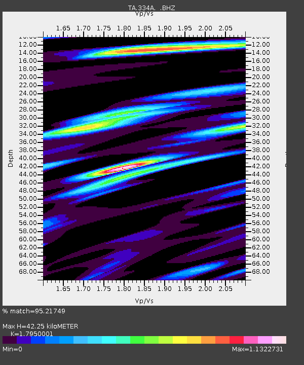
| Estimated Moho Depth: |
42.25 km |
| Estimated Crust Vp/Vs: |
1.80 |
| Assumed Crust Vp: |
6.498 km/s |
| Estimated Crust Vs: |
3.62 km/s |
| Estimated Crust Poisson's Ratio: |
0.27 |
|
| Radial Match: |
95.21749 % |
| Radial Bump: |
400 |
| Transverse Match: |
77.20182 % |
| Transverse Bump: |
400 |
| SOD ConfigId: |
319893 |
| Insert Time: |
2011-01-05 02:35:37.123 +0000 |
| GWidth: |
2.5 |
| Max Bumps: |
400 |
| Tol: |
0.001 |
|
Signal To Noise
| Channel | StoN | STA | LTA |
| TA:334A: :BHZ:20100712T00:20:48.200012Z | 27.129906 | 2.0444584E-6 | 7.535811E-8 |
| TA:334A: :BHN:20100712T00:20:48.200012Z | 32.021267 | 9.956751E-7 | 3.109418E-8 |
| TA:334A: :BHE:20100712T00:20:48.200012Z | 12.276859 | 6.697971E-7 | 5.455769E-8 |
| Arrivals |
| Ps | 5.4 SECOND |
| PpPs | 17 SECOND |
| PsPs/PpSs | 23 SECOND |


