You are here: Home > Network List > TA - USArray Transportable Network (new EarthScope stations) Stations List
> Station 634A China Grove, San Antonio TX, USA > Earthquake Result Viewer
634A China Grove, San Antonio TX, USA - Earthquake Result Viewer
| Earthquake location: |
Northern Chile |
| Earthquake latitude/longitude: |
-22.1/-68.2 |
| Earthquake time(UTC): |
2010/07/12 (193) 00:11:21 GMT |
| Earthquake Depth: |
115 km |
| Earthquake Magnitude: |
6.1 MB, 6.3 MW, 6.2 MW |
| Earthquake Catalog/Contributor: |
WHDF/NEIC |
|
| Network: |
TA USArray Transportable Network (new EarthScope stations) |
| Station: |
634A China Grove, San Antonio TX, USA |
| Lat/Lon: |
29.38 N/98.35 W |
| Elevation: |
188 m |
|
| Distance: |
58.9 deg |
| Az: |
329.214 deg |
| Baz: |
147.064 deg |
| Ray Param: |
0.062212132 |
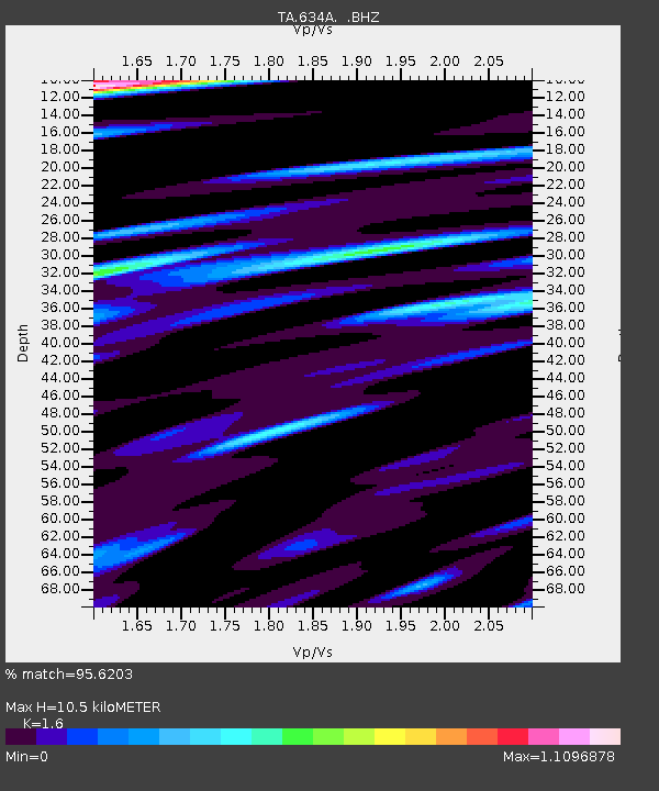
| Estimated Moho Depth: |
10.5 km |
| Estimated Crust Vp/Vs: |
1.60 |
| Assumed Crust Vp: |
6.347 km/s |
| Estimated Crust Vs: |
3.967 km/s |
| Estimated Crust Poisson's Ratio: |
0.18 |
|
| Radial Match: |
95.6203 % |
| Radial Bump: |
400 |
| Transverse Match: |
89.90768 % |
| Transverse Bump: |
400 |
| SOD ConfigId: |
319893 |
| Insert Time: |
2011-01-05 02:36:26.710 +0000 |
| GWidth: |
2.5 |
| Max Bumps: |
400 |
| Tol: |
0.001 |
|
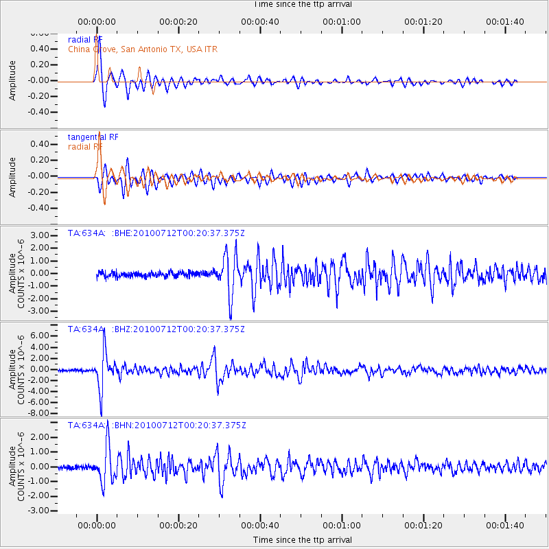
Signal To Noise
| Channel | StoN | STA | LTA |
| TA:634A: :BHZ:20100712T00:20:37.375Z | 24.656717 | 3.3484832E-6 | 1.358041E-7 |
| TA:634A: :BHN:20100712T00:20:37.375Z | 12.896573 | 1.2465109E-6 | 9.665443E-8 |
| TA:634A: :BHE:20100712T00:20:37.375Z | 8.849643 | 1.6145342E-6 | 1.8244062E-7 |
| Arrivals |
| Ps | 1.0 SECOND |
| PpPs | 4.1 SECOND |
| PsPs/PpSs | 5.1 SECOND |


