You are here: Home > Network List > TA - USArray Transportable Network (new EarthScope stations) Stations List
> Station 340A Bronson, TX, USA > Earthquake Result Viewer
340A Bronson, TX, USA - Earthquake Result Viewer
| Earthquake location: |
Northern Chile |
| Earthquake latitude/longitude: |
-22.1/-68.2 |
| Earthquake time(UTC): |
2010/07/12 (193) 00:11:21 GMT |
| Earthquake Depth: |
115 km |
| Earthquake Magnitude: |
6.1 MB, 6.3 MW, 6.2 MW |
| Earthquake Catalog/Contributor: |
WHDF/NEIC |
|
| Network: |
TA USArray Transportable Network (new EarthScope stations) |
| Station: |
340A Bronson, TX, USA |
| Lat/Lon: |
31.42 N/93.89 W |
| Elevation: |
57 m |
|
| Distance: |
58.7 deg |
| Az: |
334.302 deg |
| Baz: |
151.951 deg |
| Ray Param: |
0.062349647 |
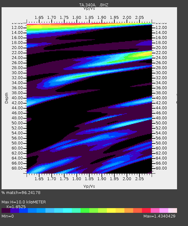
| Estimated Moho Depth: |
10.0 km |
| Estimated Crust Vp/Vs: |
1.65 |
| Assumed Crust Vp: |
6.065 km/s |
| Estimated Crust Vs: |
3.67 km/s |
| Estimated Crust Poisson's Ratio: |
0.21 |
|
| Radial Match: |
96.24178 % |
| Radial Bump: |
391 |
| Transverse Match: |
90.31789 % |
| Transverse Bump: |
400 |
| SOD ConfigId: |
319893 |
| Insert Time: |
2011-01-05 02:38:31.699 +0000 |
| GWidth: |
2.5 |
| Max Bumps: |
400 |
| Tol: |
0.001 |
|

Signal To Noise
| Channel | StoN | STA | LTA |
| TA:340A: :BHZ:20100712T00:20:35.924988Z | 73.33694 | 6.177454E-6 | 8.423387E-8 |
| TA:340A: :BHN:20100712T00:20:35.924988Z | 11.264879 | 1.636421E-6 | 1.4526752E-7 |
| TA:340A: :BHE:20100712T00:20:35.924988Z | 7.1108356 | 1.0346582E-6 | 1.4550446E-7 |
| Arrivals |
| Ps | 1.1 SECOND |
| PpPs | 4.2 SECOND |
| PsPs/PpSs | 5.3 SECOND |


