You are here: Home > Network List > TA - USArray Transportable Network (new EarthScope stations) Stations List
> Station 237A Washetta, Montalba, TX, USA > Earthquake Result Viewer
237A Washetta, Montalba, TX, USA - Earthquake Result Viewer
| Earthquake location: |
Northern Chile |
| Earthquake latitude/longitude: |
-22.1/-68.2 |
| Earthquake time(UTC): |
2010/07/12 (193) 00:11:21 GMT |
| Earthquake Depth: |
115 km |
| Earthquake Magnitude: |
6.1 MB, 6.3 MW, 6.2 MW |
| Earthquake Catalog/Contributor: |
WHDF/NEIC |
|
| Network: |
TA USArray Transportable Network (new EarthScope stations) |
| Station: |
237A Washetta, Montalba, TX, USA |
| Lat/Lon: |
32.00 N/95.81 W |
| Elevation: |
126 m |
|
| Distance: |
60.0 deg |
| Az: |
332.964 deg |
| Baz: |
150.265 deg |
| Ray Param: |
0.06150094 |
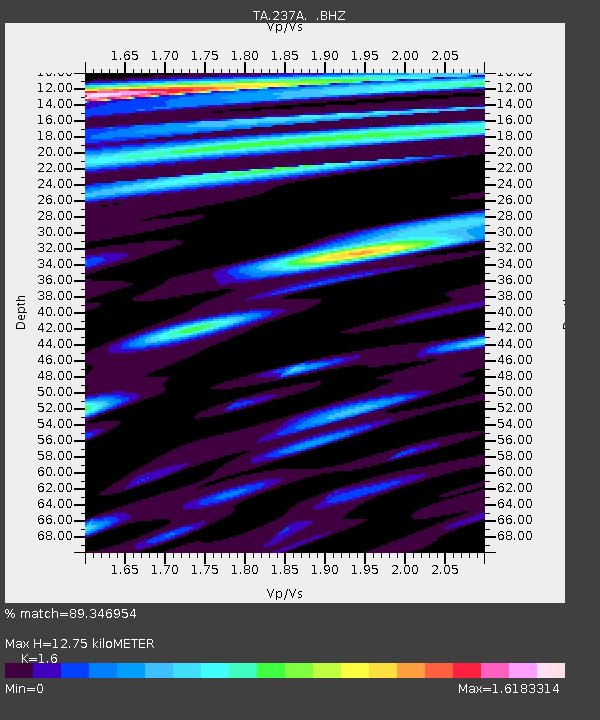
| Estimated Moho Depth: |
12.75 km |
| Estimated Crust Vp/Vs: |
1.60 |
| Assumed Crust Vp: |
6.245 km/s |
| Estimated Crust Vs: |
3.903 km/s |
| Estimated Crust Poisson's Ratio: |
0.18 |
|
| Radial Match: |
89.346954 % |
| Radial Bump: |
400 |
| Transverse Match: |
86.1147 % |
| Transverse Bump: |
400 |
| SOD ConfigId: |
319893 |
| Insert Time: |
2011-01-05 02:38:38.967 +0000 |
| GWidth: |
2.5 |
| Max Bumps: |
400 |
| Tol: |
0.001 |
|
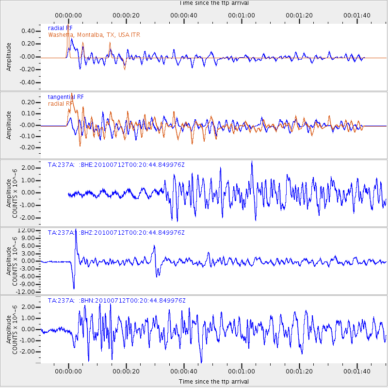
Signal To Noise
| Channel | StoN | STA | LTA |
| TA:237A: :BHZ:20100712T00:20:44.849976Z | 36.769085 | 4.67634E-6 | 1.271813E-7 |
| TA:237A: :BHN:20100712T00:20:44.849976Z | 4.476708 | 7.9402486E-7 | 1.7736804E-7 |
| TA:237A: :BHE:20100712T00:20:44.849976Z | 2.1675005 | 3.809716E-7 | 1.757654E-7 |
| Arrivals |
| Ps | 1.3 SECOND |
| PpPs | 5.1 SECOND |
| PsPs/PpSs | 6.3 SECOND |


