You are here: Home > Network List > TA - USArray Transportable Network (new EarthScope stations) Stations List
> Station W35A Tecumseh, OK, USA > Earthquake Result Viewer
W35A Tecumseh, OK, USA - Earthquake Result Viewer
| Earthquake location: |
Northern Chile |
| Earthquake latitude/longitude: |
-22.1/-68.2 |
| Earthquake time(UTC): |
2010/07/12 (193) 00:11:21 GMT |
| Earthquake Depth: |
115 km |
| Earthquake Magnitude: |
6.1 MB, 6.3 MW, 6.2 MW |
| Earthquake Catalog/Contributor: |
WHDF/NEIC |
|
| Network: |
TA USArray Transportable Network (new EarthScope stations) |
| Station: |
W35A Tecumseh, OK, USA |
| Lat/Lon: |
35.15 N/96.87 W |
| Elevation: |
322 m |
|
| Distance: |
63.1 deg |
| Az: |
333.863 deg |
| Baz: |
150.106 deg |
| Ray Param: |
0.05945069 |
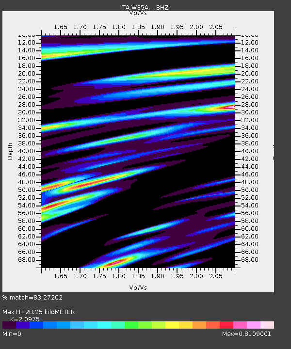
| Estimated Moho Depth: |
28.25 km |
| Estimated Crust Vp/Vs: |
2.10 |
| Assumed Crust Vp: |
6.426 km/s |
| Estimated Crust Vs: |
3.064 km/s |
| Estimated Crust Poisson's Ratio: |
0.35 |
|
| Radial Match: |
83.27202 % |
| Radial Bump: |
400 |
| Transverse Match: |
76.52605 % |
| Transverse Bump: |
400 |
| SOD ConfigId: |
319893 |
| Insert Time: |
2011-01-05 02:39:57.267 +0000 |
| GWidth: |
2.5 |
| Max Bumps: |
400 |
| Tol: |
0.001 |
|

Signal To Noise
| Channel | StoN | STA | LTA |
| TA:W35A: :BHZ:20100712T00:21:06.075012Z | 22.908167 | 1.8217015E-6 | 7.952192E-8 |
| TA:W35A: :BHN:20100712T00:21:06.075012Z | 8.05732 | 8.275369E-7 | 1.0270622E-7 |
| TA:W35A: :BHE:20100712T00:21:06.075012Z | 6.277263 | 4.01313E-7 | 6.39312E-8 |
| Arrivals |
| Ps | 5.0 SECOND |
| PpPs | 13 SECOND |
| PsPs/PpSs | 18 SECOND |


