You are here: Home > Network List > TA - USArray Transportable Network (new EarthScope stations) Stations List
> Station Y39A Lockesburg, AR, USA > Earthquake Result Viewer
Y39A Lockesburg, AR, USA - Earthquake Result Viewer
| Earthquake location: |
Northern Chile |
| Earthquake latitude/longitude: |
-22.1/-68.2 |
| Earthquake time(UTC): |
2010/07/12 (193) 00:11:21 GMT |
| Earthquake Depth: |
115 km |
| Earthquake Magnitude: |
6.1 MB, 6.3 MW, 6.2 MW |
| Earthquake Catalog/Contributor: |
WHDF/NEIC |
|
| Network: |
TA USArray Transportable Network (new EarthScope stations) |
| Station: |
Y39A Lockesburg, AR, USA |
| Lat/Lon: |
33.94 N/94.09 W |
| Elevation: |
108 m |
|
| Distance: |
61.0 deg |
| Az: |
335.482 deg |
| Baz: |
152.435 deg |
| Ray Param: |
0.06084514 |
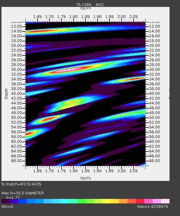
| Estimated Moho Depth: |
30.0 km |
| Estimated Crust Vp/Vs: |
1.77 |
| Assumed Crust Vp: |
6.245 km/s |
| Estimated Crust Vs: |
3.528 km/s |
| Estimated Crust Poisson's Ratio: |
0.27 |
|
| Radial Match: |
93.514435 % |
| Radial Bump: |
400 |
| Transverse Match: |
86.31425 % |
| Transverse Bump: |
400 |
| SOD ConfigId: |
319893 |
| Insert Time: |
2011-01-05 02:40:58.607 +0000 |
| GWidth: |
2.5 |
| Max Bumps: |
400 |
| Tol: |
0.001 |
|

Signal To Noise
| Channel | StoN | STA | LTA |
| TA:Y39A: :BHZ:20100712T00:20:51.650024Z | 36.387352 | 2.7857318E-6 | 7.65577E-8 |
| TA:Y39A: :BHN:20100712T00:20:51.650024Z | 22.271616 | 1.6727918E-6 | 7.510869E-8 |
| TA:Y39A: :BHE:20100712T00:20:51.650024Z | 11.586798 | 8.7126915E-7 | 7.519499E-8 |
| Arrivals |
| Ps | 3.9 SECOND |
| PpPs | 13 SECOND |
| PsPs/PpSs | 17 SECOND |


