You are here: Home > Network List > TA - USArray Transportable Network (new EarthScope stations) Stations List
> Station O36A Bolckow, MO, USA > Earthquake Result Viewer
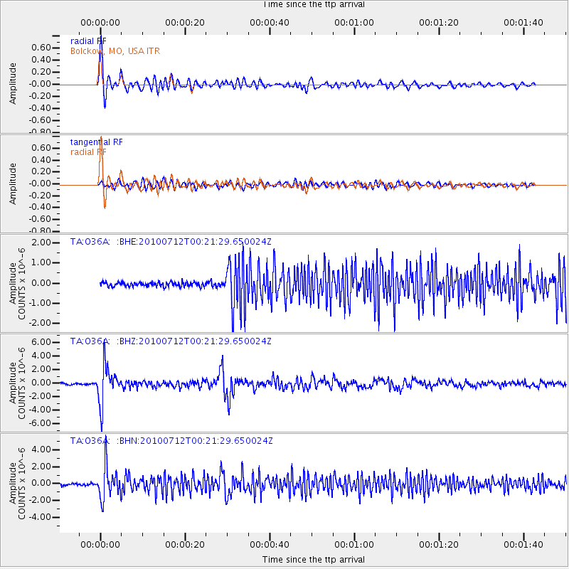
O36A Bolckow, MO, USA - Earthquake Result Viewer

| Earthquake location: |
Northern Chile |
| Earthquake latitude/longitude: |
-22.1/-68.2 |
| Earthquake time(UTC): |
2010/07/12 (193) 00:11:21 GMT |
| Earthquake Depth: |
115 km |
| Earthquake Magnitude: |
6.1 MB, 6.3 MW, 6.2 MW |
| Earthquake Catalog/Contributor: |
WHDF/NEIC |
|
| Network: |
TA USArray Transportable Network (new EarthScope stations) |
| Station: |
O36A Bolckow, MO, USA |
| Lat/Lon: |
40.13 N/94.96 W |
| Elevation: |
306 m |
|
| Distance: |
66.8 deg |
| Az: |
337.947 deg |
| Baz: |
152.998 deg |
| Ray Param: |
0.05707435 |
| Estimated Moho Depth: |
41.75 km |
| Estimated Crust Vp/Vs: |
1.74 |
| Assumed Crust Vp: |
6.498 km/s |
| Estimated Crust Vs: |
3.745 km/s |
| Estimated Crust Poisson's Ratio: |
0.25 |
|
| Radial Match: |
93.679405 % |
| Radial Bump: |
400 |
| Transverse Match: |
75.54103 % |
| Transverse Bump: |
400 |
| SOD ConfigId: |
319893 |
| Insert Time: |
2011-01-05 02:42:06.387 +0000 |
| GWidth: |
2.5 |
| Max Bumps: |
400 |
| Tol: |
0.001 |
|
Signal To Noise
| Channel | StoN | STA | LTA |
| TA:O36A: :BHZ:20100712T00:21:29.650024Z | 26.833006 | 2.7738054E-6 | 1.0337289E-7 |
| TA:O36A: :BHN:20100712T00:21:29.650024Z | 15.775002 | 1.8908346E-6 | 1.1986272E-7 |
| TA:O36A: :BHE:20100712T00:21:29.650024Z | 11.466907 | 1.1967539E-6 | 1.04365895E-7 |
| Arrivals |
| Ps | 4.9 SECOND |
| PpPs | 17 SECOND |
| PsPs/PpSs | 22 SECOND |


