You are here: Home > Network List > AE - Arizona Broadband Seismic Network Stations List
> Station W18A Petrified Forest, AZ, USA > Earthquake Result Viewer
W18A Petrified Forest, AZ, USA - Earthquake Result Viewer
| Earthquake location: |
Colombia |
| Earthquake latitude/longitude: |
5.3/-76.7 |
| Earthquake time(UTC): |
2023/08/27 (239) 21:44:59 GMT |
| Earthquake Depth: |
15 km |
| Earthquake Magnitude: |
5.7 Mww |
| Earthquake Catalog/Contributor: |
NEIC PDE/us |
|
| Network: |
AE Arizona Broadband Seismic Network |
| Station: |
W18A Petrified Forest, AZ, USA |
| Lat/Lon: |
35.12 N/109.74 W |
| Elevation: |
1750 m |
|
| Distance: |
42.5 deg |
| Az: |
318.582 deg |
| Baz: |
126.531 deg |
| Ray Param: |
0.07312518 |
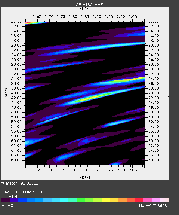
| Estimated Moho Depth: |
10.0 km |
| Estimated Crust Vp/Vs: |
1.60 |
| Assumed Crust Vp: |
6.496 km/s |
| Estimated Crust Vs: |
4.06 km/s |
| Estimated Crust Poisson's Ratio: |
0.18 |
|
| Radial Match: |
91.82311 % |
| Radial Bump: |
340 |
| Transverse Match: |
75.70959 % |
| Transverse Bump: |
400 |
| SOD ConfigId: |
31937991 |
| Insert Time: |
2023-09-10 21:46:57.060 +0000 |
| GWidth: |
2.5 |
| Max Bumps: |
400 |
| Tol: |
0.001 |
|

Signal To Noise
| Channel | StoN | STA | LTA |
| AE:W18A: :HHZ:20230827T21:52:23.428998Z | 6.648338 | 2.5401417E-7 | 3.820717E-8 |
| AE:W18A: :HHN:20230827T21:52:23.428998Z | 1.2479599 | 7.968702E-8 | 6.385384E-8 |
| AE:W18A: :HHE:20230827T21:52:23.428998Z | 1.1245097 | 7.7211695E-8 | 6.8662544E-8 |
| Arrivals |
| Ps | 1.0 SECOND |
| PpPs | 3.7 SECOND |
| PsPs/PpSs | 4.7 SECOND |


