You are here: Home > Network List > US - United States National Seismic Network Stations List
> Station LRAL Lakeview Retreat, Alabama, USA > Earthquake Result Viewer
LRAL Lakeview Retreat, Alabama, USA - Earthquake Result Viewer
| Earthquake location: |
Northern Chile |
| Earthquake latitude/longitude: |
-22.1/-68.2 |
| Earthquake time(UTC): |
2010/07/12 (193) 00:11:21 GMT |
| Earthquake Depth: |
115 km |
| Earthquake Magnitude: |
6.1 MB, 6.3 MW, 6.2 MW |
| Earthquake Catalog/Contributor: |
WHDF/NEIC |
|
| Network: |
US United States National Seismic Network |
| Station: |
LRAL Lakeview Retreat, Alabama, USA |
| Lat/Lon: |
33.03 N/87.00 W |
| Elevation: |
130 m |
|
| Distance: |
57.7 deg |
| Az: |
341.345 deg |
| Baz: |
159.327 deg |
| Ray Param: |
0.06296148 |
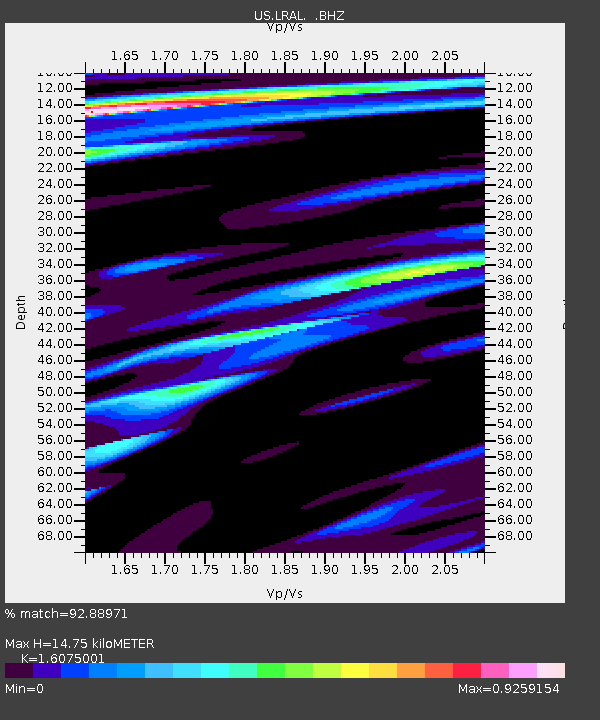
| Estimated Moho Depth: |
14.75 km |
| Estimated Crust Vp/Vs: |
1.61 |
| Assumed Crust Vp: |
6.565 km/s |
| Estimated Crust Vs: |
4.084 km/s |
| Estimated Crust Poisson's Ratio: |
0.18 |
|
| Radial Match: |
92.88971 % |
| Radial Bump: |
400 |
| Transverse Match: |
81.82305 % |
| Transverse Bump: |
400 |
| SOD ConfigId: |
319893 |
| Insert Time: |
2011-01-05 02:47:07.032 +0000 |
| GWidth: |
2.5 |
| Max Bumps: |
400 |
| Tol: |
0.001 |
|

Signal To Noise
| Channel | StoN | STA | LTA |
| US:LRAL: :BHZ:20100712T00:20:29.375Z | 24.334417 | 1.7557802E-6 | 7.215213E-8 |
| US:LRAL: :BHN:20100712T00:20:29.375Z | 7.7646675 | 5.7992816E-7 | 7.468808E-8 |
| US:LRAL: :BHE:20100712T00:20:29.375Z | 3.6070275 | 1.7808166E-7 | 4.937075E-8 |
| Arrivals |
| Ps | 1.4 SECOND |
| PpPs | 5.5 SECOND |
| PsPs/PpSs | 7.0 SECOND |


