You are here: Home > Network List > US - United States National Seismic Network Stations List
> Station DGMT Dagmar, Montana, USA > Earthquake Result Viewer
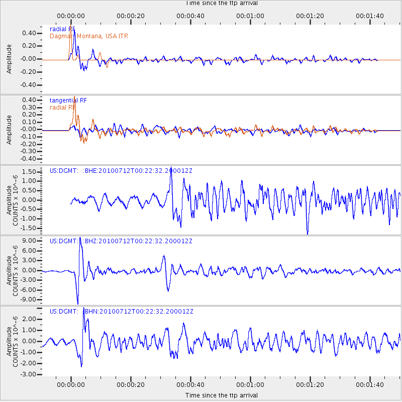
DGMT Dagmar, Montana, USA - Earthquake Result Viewer
*The percent match for this event was below the threshold and hence no stack was calculated.
| Earthquake location: |
Northern Chile |
| Earthquake latitude/longitude: |
-22.1/-68.2 |
| Earthquake time(UTC): |
2010/07/12 (193) 00:11:21 GMT |
| Earthquake Depth: |
115 km |
| Earthquake Magnitude: |
6.1 MB, 6.3 MW, 6.2 MW |
| Earthquake Catalog/Contributor: |
WHDF/NEIC |
|
| Network: |
US United States National Seismic Network |
| Station: |
DGMT Dagmar, Montana, USA |
| Lat/Lon: |
48.47 N/104.20 W |
| Elevation: |
0.0 m |
|
| Distance: |
77.3 deg |
| Az: |
336.375 deg |
| Baz: |
146.063 deg |
| Ray Param: |
$rayparam |
*The percent match for this event was below the threshold and hence was not used in the summary stack. |
|
| Radial Match: |
91.74133 % |
| Radial Bump: |
374 |
| Transverse Match: |
80.548134 % |
| Transverse Bump: |
400 |
| SOD ConfigId: |
319893 |
| Insert Time: |
2011-01-05 02:47:30.574 +0000 |
| GWidth: |
2.5 |
| Max Bumps: |
400 |
| Tol: |
0.001 |
|
Signal To Noise
| Channel | StoN | STA | LTA |
| US:DGMT: :BHZ:20100712T00:22:32.200012Z | 39.792095 | 4.894469E-6 | 1.2300103E-7 |
| US:DGMT: :BHN:20100712T00:22:32.200012Z | 6.6725044 | 1.182238E-6 | 1.7718054E-7 |
| US:DGMT: :BHE:20100712T00:22:32.200012Z | 3.2968838 | 6.569823E-7 | 1.9927371E-7 |
| Arrivals |
| Ps | |
| PpPs | |
| PsPs/PpSs | |


