You are here: Home > Network List > US - United States National Seismic Network Stations List
> Station TZTN Tazewell, Tennessee, USA > Earthquake Result Viewer
TZTN Tazewell, Tennessee, USA - Earthquake Result Viewer

| Earthquake location: |
Northern Chile |
| Earthquake latitude/longitude: |
-22.1/-68.2 |
| Earthquake time(UTC): |
2010/07/12 (193) 00:11:21 GMT |
| Earthquake Depth: |
115 km |
| Earthquake Magnitude: |
6.1 MB, 6.3 MW, 6.2 MW |
| Earthquake Catalog/Contributor: |
WHDF/NEIC |
|
| Network: |
US United States National Seismic Network |
| Station: |
TZTN Tazewell, Tennessee, USA |
| Lat/Lon: |
36.54 N/83.55 W |
| Elevation: |
394 m |
|
| Distance: |
60.1 deg |
| Az: |
345.787 deg |
| Baz: |
163.58 deg |
| Ray Param: |
0.061387416 |
| Estimated Moho Depth: |
12.5 km |
| Estimated Crust Vp/Vs: |
2.07 |
| Assumed Crust Vp: |
6.476 km/s |
| Estimated Crust Vs: |
3.128 km/s |
| Estimated Crust Poisson's Ratio: |
0.35 |
|
| Radial Match: |
93.77726 % |
| Radial Bump: |
400 |
| Transverse Match: |
87.667015 % |
| Transverse Bump: |
400 |
| SOD ConfigId: |
319893 |
| Insert Time: |
2011-01-05 02:47:54.120 +0000 |
| GWidth: |
2.5 |
| Max Bumps: |
400 |
| Tol: |
0.001 |
|
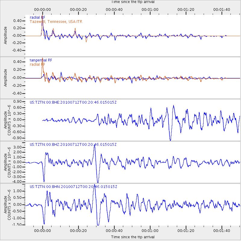
Signal To Noise
| Channel | StoN | STA | LTA |
| US:TZTN:00:BHZ:20100712T00:20:46.015015Z | 18.650059 | 1.6351564E-6 | 8.7675666E-8 |
| US:TZTN:00:BHN:20100712T00:20:46.015015Z | 10.180666 | 6.7369564E-7 | 6.6174024E-8 |
| US:TZTN:00:BHE:20100712T00:20:46.015015Z | 2.4669573 | 1.4545661E-7 | 5.8961945E-8 |
| Arrivals |
| Ps | 2.2 SECOND |
| PpPs | 5.7 SECOND |
| PsPs/PpSs | 7.8 SECOND |


