You are here: Home > Network List > N4 - Central and EAstern US Network Stations List
> Station P53A Whipple, OH, USA > Earthquake Result Viewer
P53A Whipple, OH, USA - Earthquake Result Viewer
| Earthquake location: |
Colombia |
| Earthquake latitude/longitude: |
5.3/-76.7 |
| Earthquake time(UTC): |
2023/08/27 (239) 21:44:59 GMT |
| Earthquake Depth: |
15 km |
| Earthquake Magnitude: |
5.7 Mww |
| Earthquake Catalog/Contributor: |
NEIC PDE/us |
|
| Network: |
N4 Central and EAstern US Network |
| Station: |
P53A Whipple, OH, USA |
| Lat/Lon: |
39.49 N/81.39 W |
| Elevation: |
270 m |
|
| Distance: |
34.3 deg |
| Az: |
353.534 deg |
| Baz: |
171.669 deg |
| Ray Param: |
0.07782079 |
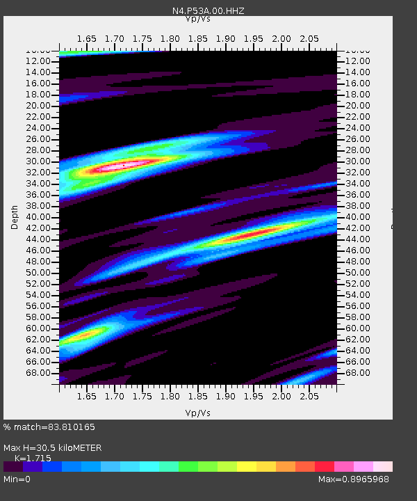
| Estimated Moho Depth: |
30.5 km |
| Estimated Crust Vp/Vs: |
1.72 |
| Assumed Crust Vp: |
6.207 km/s |
| Estimated Crust Vs: |
3.619 km/s |
| Estimated Crust Poisson's Ratio: |
0.24 |
|
| Radial Match: |
83.810165 % |
| Radial Bump: |
389 |
| Transverse Match: |
54.235596 % |
| Transverse Bump: |
400 |
| SOD ConfigId: |
31937991 |
| Insert Time: |
2023-09-10 22:05:04.288 +0000 |
| GWidth: |
2.5 |
| Max Bumps: |
400 |
| Tol: |
0.001 |
|

Signal To Noise
| Channel | StoN | STA | LTA |
| N4:P53A:00:HHZ:20230827T21:51:14.190015Z | 4.131144 | 5.3867745E-7 | 1.3039426E-7 |
| N4:P53A:00:HH1:20230827T21:51:14.190015Z | 3.1195393 | 2.7937173E-7 | 8.955545E-8 |
| N4:P53A:00:HH2:20230827T21:51:14.190015Z | 0.84433043 | 1.5412539E-7 | 1.8254156E-7 |
| Arrivals |
| Ps | 3.8 SECOND |
| PpPs | 12 SECOND |
| PsPs/PpSs | 16 SECOND |


