You are here: Home > Network List > N4 - Central and EAstern US Network Stations List
> Station U56A King, NC, USA > Earthquake Result Viewer
U56A King, NC, USA - Earthquake Result Viewer
| Earthquake location: |
Colombia |
| Earthquake latitude/longitude: |
5.3/-76.7 |
| Earthquake time(UTC): |
2023/08/27 (239) 21:44:59 GMT |
| Earthquake Depth: |
15 km |
| Earthquake Magnitude: |
5.7 Mww |
| Earthquake Catalog/Contributor: |
NEIC PDE/us |
|
| Network: |
N4 Central and EAstern US Network |
| Station: |
U56A King, NC, USA |
| Lat/Lon: |
36.35 N/80.38 W |
| Elevation: |
363 m |
|
| Distance: |
31.0 deg |
| Az: |
354.214 deg |
| Baz: |
172.858 deg |
| Ray Param: |
0.07921177 |
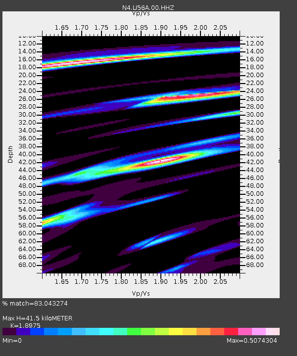
| Estimated Moho Depth: |
41.5 km |
| Estimated Crust Vp/Vs: |
1.90 |
| Assumed Crust Vp: |
6.159 km/s |
| Estimated Crust Vs: |
3.246 km/s |
| Estimated Crust Poisson's Ratio: |
0.31 |
|
| Radial Match: |
83.043274 % |
| Radial Bump: |
400 |
| Transverse Match: |
48.187595 % |
| Transverse Bump: |
400 |
| SOD ConfigId: |
31937991 |
| Insert Time: |
2023-09-10 22:05:56.146 +0000 |
| GWidth: |
2.5 |
| Max Bumps: |
400 |
| Tol: |
0.001 |
|

Signal To Noise
| Channel | StoN | STA | LTA |
| N4:U56A:00:HHZ:20230827T21:50:46.159986Z | 5.2791915 | 5.338812E-7 | 1.0112934E-7 |
| N4:U56A:00:HH1:20230827T21:50:46.159986Z | 3.2347937 | 3.978926E-7 | 1.23004E-7 |
| N4:U56A:00:HH2:20230827T21:50:46.159986Z | 1.2164662 | 1.1500657E-7 | 9.454153E-8 |
| Arrivals |
| Ps | 6.5 SECOND |
| PpPs | 18 SECOND |
| PsPs/PpSs | 25 SECOND |


