You are here: Home > Network List > US - United States National Seismic Network Stations List
> Station EGMT Eagleton, Montana, USA > Earthquake Result Viewer
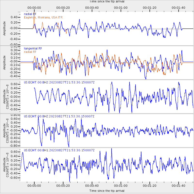
EGMT Eagleton, Montana, USA - Earthquake Result Viewer
*The percent match for this event was below the threshold and hence no stack was calculated.
| Earthquake location: |
Colombia |
| Earthquake latitude/longitude: |
5.3/-76.7 |
| Earthquake time(UTC): |
2023/08/27 (239) 21:44:59 GMT |
| Earthquake Depth: |
15 km |
| Earthquake Magnitude: |
5.7 Mww |
| Earthquake Catalog/Contributor: |
NEIC PDE/us |
|
| Network: |
US United States National Seismic Network |
| Station: |
EGMT Eagleton, Montana, USA |
| Lat/Lon: |
48.02 N/109.75 W |
| Elevation: |
1055 m |
|
| Distance: |
51.0 deg |
| Az: |
331.904 deg |
| Baz: |
135.689 deg |
| Ray Param: |
$rayparam |
*The percent match for this event was below the threshold and hence was not used in the summary stack. |
|
| Radial Match: |
54.91837 % |
| Radial Bump: |
400 |
| Transverse Match: |
65.38632 % |
| Transverse Bump: |
400 |
| SOD ConfigId: |
31937991 |
| Insert Time: |
2023-09-10 22:16:03.286 +0000 |
| GWidth: |
2.5 |
| Max Bumps: |
400 |
| Tol: |
0.001 |
|
Signal To Noise
| Channel | StoN | STA | LTA |
| US:EGMT:00:BHZ:20230827T21:53:30.150007Z | 3.3421733 | 3.139034E-7 | 9.392194E-8 |
| US:EGMT:00:BH1:20230827T21:53:30.150007Z | 0.6542135 | 1.5553368E-7 | 2.3774147E-7 |
| US:EGMT:00:BH2:20230827T21:53:30.150007Z | 0.85721153 | 1.7245077E-7 | 2.0117645E-7 |
| Arrivals |
| Ps | |
| PpPs | |
| PsPs/PpSs | |


