You are here: Home > Network List > AK - Alaska Regional Network Stations List
> Station F15K North Star Ditch, AK, USA > Earthquake Result Viewer
F15K North Star Ditch, AK, USA - Earthquake Result Viewer
| Earthquake location: |
Bali Sea |
| Earthquake latitude/longitude: |
-6.8/116.5 |
| Earthquake time(UTC): |
2023/08/28 (240) 19:55:31 GMT |
| Earthquake Depth: |
514 km |
| Earthquake Magnitude: |
7.1 Mww |
| Earthquake Catalog/Contributor: |
NEIC PDE/us |
|
| Network: |
AK Alaska Regional Network |
| Station: |
F15K North Star Ditch, AK, USA |
| Lat/Lon: |
65.71 N/164.65 W |
| Elevation: |
388 m |
|
| Distance: |
91.6 deg |
| Az: |
23.952 deg |
| Baz: |
257.044 deg |
| Ray Param: |
0.04126839 |
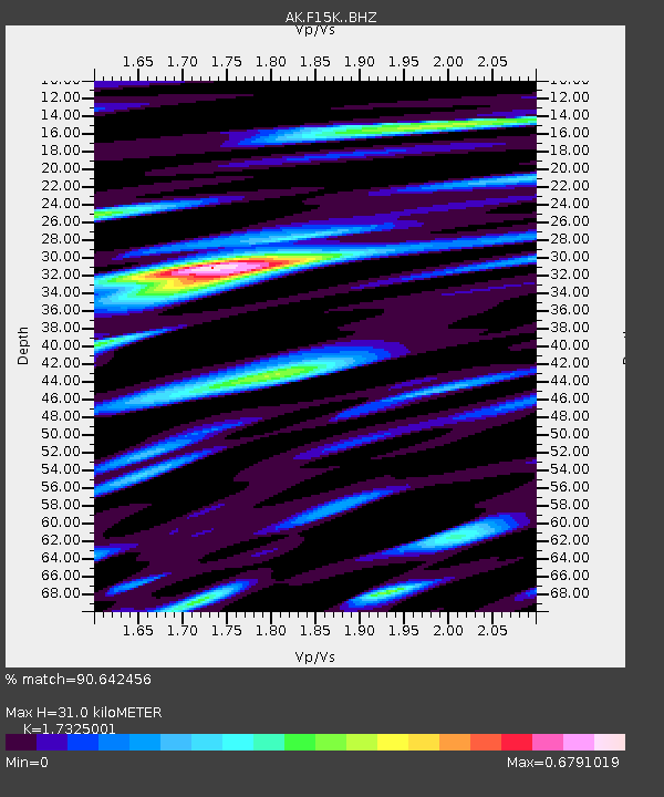
| Estimated Moho Depth: |
31.0 km |
| Estimated Crust Vp/Vs: |
1.73 |
| Assumed Crust Vp: |
6.276 km/s |
| Estimated Crust Vs: |
3.622 km/s |
| Estimated Crust Poisson's Ratio: |
0.25 |
|
| Radial Match: |
90.642456 % |
| Radial Bump: |
400 |
| Transverse Match: |
69.4539 % |
| Transverse Bump: |
400 |
| SOD ConfigId: |
31937991 |
| Insert Time: |
2023-09-11 19:57:23.674 +0000 |
| GWidth: |
2.5 |
| Max Bumps: |
400 |
| Tol: |
0.001 |
|

Signal To Noise
| Channel | StoN | STA | LTA |
| AK:F15K: :BHZ:20230828T20:07:12.000016Z | 37.677773 | 3.0325905E-6 | 8.048752E-8 |
| AK:F15K: :BHN:20230828T20:07:12.000016Z | 3.8841217 | 2.1650382E-7 | 5.574074E-8 |
| AK:F15K: :BHE:20230828T20:07:12.000016Z | 9.045173 | 8.114754E-7 | 8.9713645E-8 |
| Arrivals |
| Ps | 3.7 SECOND |
| PpPs | 13 SECOND |
| PsPs/PpSs | 17 SECOND |


