You are here: Home > Network List > AK - Alaska Regional Network Stations List
> Station GAMB Gambell Broadband > Earthquake Result Viewer
GAMB Gambell Broadband - Earthquake Result Viewer
| Earthquake location: |
Bali Sea |
| Earthquake latitude/longitude: |
-6.8/116.5 |
| Earthquake time(UTC): |
2023/08/28 (240) 19:55:31 GMT |
| Earthquake Depth: |
514 km |
| Earthquake Magnitude: |
7.1 Mww |
| Earthquake Catalog/Contributor: |
NEIC PDE/us |
|
| Network: |
AK Alaska Regional Network |
| Station: |
GAMB Gambell Broadband |
| Lat/Lon: |
63.78 N/171.70 W |
| Elevation: |
10 m |
|
| Distance: |
88.1 deg |
| Az: |
24.97 deg |
| Baz: |
250.674 deg |
| Ray Param: |
0.04172549 |
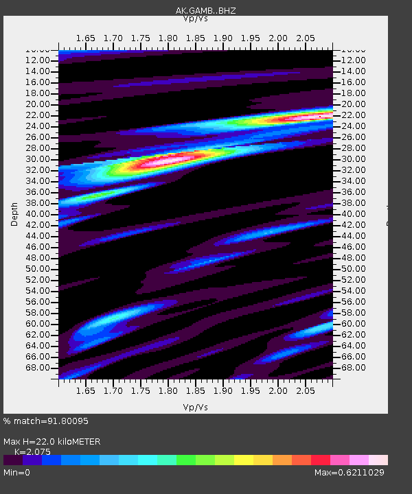
| Estimated Moho Depth: |
22.0 km |
| Estimated Crust Vp/Vs: |
2.08 |
| Assumed Crust Vp: |
6.24 km/s |
| Estimated Crust Vs: |
3.007 km/s |
| Estimated Crust Poisson's Ratio: |
0.35 |
|
| Radial Match: |
91.80095 % |
| Radial Bump: |
400 |
| Transverse Match: |
79.3798 % |
| Transverse Bump: |
400 |
| SOD ConfigId: |
31937991 |
| Insert Time: |
2023-09-11 19:57:33.414 +0000 |
| GWidth: |
2.5 |
| Max Bumps: |
400 |
| Tol: |
0.001 |
|

Signal To Noise
| Channel | StoN | STA | LTA |
| AK:GAMB: :BHZ:20230828T20:06:56.128007Z | 30.270643 | 4.4119533E-6 | 1.4575023E-7 |
| AK:GAMB: :BHN:20230828T20:06:56.128007Z | 2.6577165 | 3.574674E-7 | 1.3450172E-7 |
| AK:GAMB: :BHE:20230828T20:06:56.128007Z | 12.22143 | 1.4062992E-6 | 1.1506831E-7 |
| Arrivals |
| Ps | 3.9 SECOND |
| PpPs | 11 SECOND |
| PsPs/PpSs | 15 SECOND |


