You are here: Home > Network List > AK - Alaska Regional Network Stations List
> Station M20K Styx River, AK, USA > Earthquake Result Viewer
M20K Styx River, AK, USA - Earthquake Result Viewer
| Earthquake location: |
Bali Sea |
| Earthquake latitude/longitude: |
-6.8/116.5 |
| Earthquake time(UTC): |
2023/08/28 (240) 19:55:31 GMT |
| Earthquake Depth: |
514 km |
| Earthquake Magnitude: |
7.1 Mww |
| Earthquake Catalog/Contributor: |
NEIC PDE/us |
|
| Network: |
AK Alaska Regional Network |
| Station: |
M20K Styx River, AK, USA |
| Lat/Lon: |
61.88 N/153.13 W |
| Elevation: |
1107 m |
|
| Distance: |
96.1 deg |
| Az: |
28.452 deg |
| Baz: |
267.075 deg |
| Ray Param: |
0.04007206 |
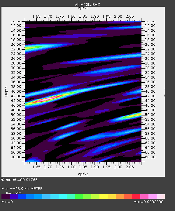
| Estimated Moho Depth: |
43.0 km |
| Estimated Crust Vp/Vs: |
1.70 |
| Assumed Crust Vp: |
6.566 km/s |
| Estimated Crust Vs: |
3.874 km/s |
| Estimated Crust Poisson's Ratio: |
0.23 |
|
| Radial Match: |
89.91766 % |
| Radial Bump: |
400 |
| Transverse Match: |
77.62713 % |
| Transverse Bump: |
400 |
| SOD ConfigId: |
31937991 |
| Insert Time: |
2023-09-11 19:58:04.114 +0000 |
| GWidth: |
2.5 |
| Max Bumps: |
400 |
| Tol: |
0.001 |
|

Signal To Noise
| Channel | StoN | STA | LTA |
| AK:M20K: :BHZ:20230828T20:07:32.479997Z | 27.70168 | 2.457602E-6 | 8.871672E-8 |
| AK:M20K: :BHN:20230828T20:07:32.479997Z | 2.1747413 | 2.0758141E-7 | 9.545108E-8 |
| AK:M20K: :BHE:20230828T20:07:32.479997Z | 9.82141 | 6.746955E-7 | 6.8696394E-8 |
| Arrivals |
| Ps | 4.6 SECOND |
| PpPs | 17 SECOND |
| PsPs/PpSs | 22 SECOND |


