You are here: Home > Network List > AV - Alaska Volcano Observatory Stations List
> Station MAPS Pakushin Southeast, Makushin Volcano, Alaska > Earthquake Result Viewer
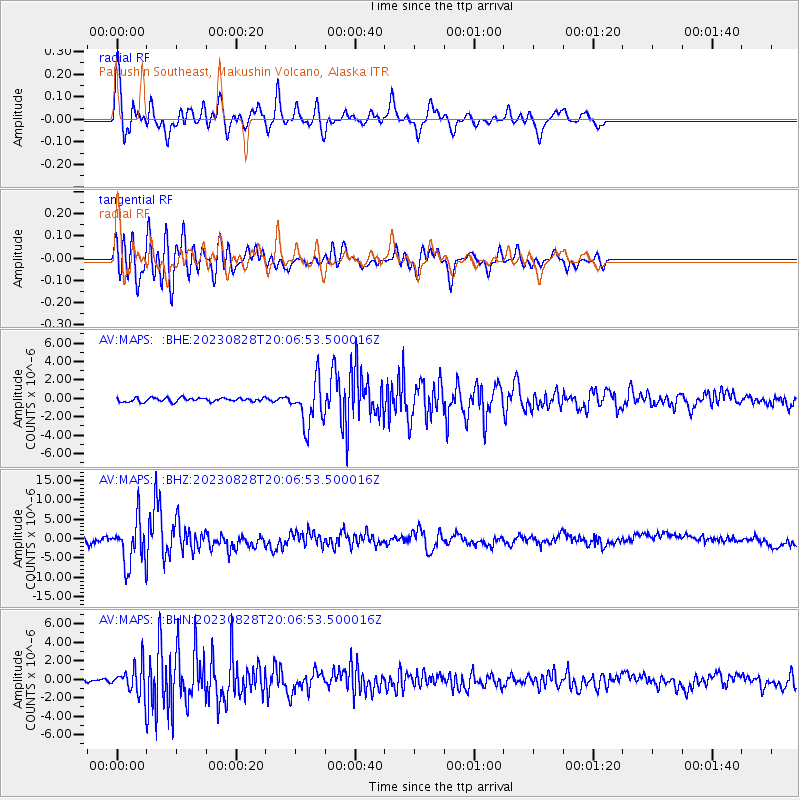
MAPS Pakushin Southeast, Makushin Volcano, Alaska - Earthquake Result Viewer
| Earthquake location: |
Bali Sea |
| Earthquake latitude/longitude: |
-6.8/116.5 |
| Earthquake time(UTC): |
2023/08/28 (240) 19:55:31 GMT |
| Earthquake Depth: |
514 km |
| Earthquake Magnitude: |
7.1 Mww |
| Earthquake Catalog/Contributor: |
NEIC PDE/us |
|
| Network: |
AV Alaska Volcano Observatory |
| Station: |
MAPS Pakushin Southeast, Makushin Volcano, Alaska |
| Lat/Lon: |
53.81 N/166.94 W |
| Elevation: |
333 m |
|
| Distance: |
87.5 deg |
| Az: |
35.257 deg |
| Baz: |
255.145 deg |
| Ray Param: |
0.041839518 |
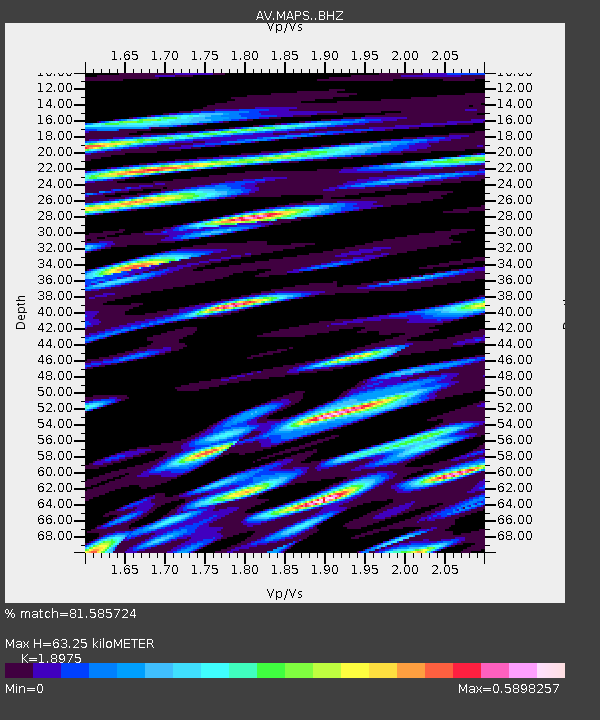
| Estimated Moho Depth: |
63.25 km |
| Estimated Crust Vp/Vs: |
1.90 |
| Assumed Crust Vp: |
3.943 km/s |
| Estimated Crust Vs: |
2.078 km/s |
| Estimated Crust Poisson's Ratio: |
0.31 |
|
| Radial Match: |
81.585724 % |
| Radial Bump: |
400 |
| Transverse Match: |
71.173874 % |
| Transverse Bump: |
400 |
| SOD ConfigId: |
31937991 |
| Insert Time: |
2023-09-11 20:01:19.139 +0000 |
| GWidth: |
2.5 |
| Max Bumps: |
400 |
| Tol: |
0.001 |
|
Signal To Noise
| Channel | StoN | STA | LTA |
| AV:MAPS: :BHZ:20230828T20:06:53.500016Z | 6.118477 | 5.716248E-6 | 9.342599E-7 |
| AV:MAPS: :BHN:20230828T20:06:53.500016Z | 7.3257823 | 1.4846761E-6 | 2.0266452E-7 |
| AV:MAPS: :BHE:20230828T20:06:53.500016Z | 11.551823 | 2.423415E-6 | 2.0978638E-7 |
| Arrivals |
| Ps | 14 SECOND |
| PpPs | 46 SECOND |
| PsPs/PpSs | 61 SECOND |


