You are here: Home > Network List > AV - Alaska Volcano Observatory Stations List
> Station S12K Black Hills, AK, USA > Earthquake Result Viewer
S12K Black Hills, AK, USA - Earthquake Result Viewer
| Earthquake location: |
Bali Sea |
| Earthquake latitude/longitude: |
-6.8/116.5 |
| Earthquake time(UTC): |
2023/08/28 (240) 19:55:31 GMT |
| Earthquake Depth: |
514 km |
| Earthquake Magnitude: |
7.1 Mww |
| Earthquake Catalog/Contributor: |
NEIC PDE/us |
|
| Network: |
AV Alaska Volcano Observatory |
| Station: |
S12K Black Hills, AK, USA |
| Lat/Lon: |
55.70 N/162.06 W |
| Elevation: |
411 m |
|
| Distance: |
90.7 deg |
| Az: |
34.037 deg |
| Baz: |
259.104 deg |
| Ray Param: |
0.04142768 |
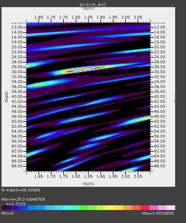
| Estimated Moho Depth: |
29.0 km |
| Estimated Crust Vp/Vs: |
1.82 |
| Assumed Crust Vp: |
5.989 km/s |
| Estimated Crust Vs: |
3.286 km/s |
| Estimated Crust Poisson's Ratio: |
0.28 |
|
| Radial Match: |
85.40589 % |
| Radial Bump: |
400 |
| Transverse Match: |
82.98392 % |
| Transverse Bump: |
400 |
| SOD ConfigId: |
31937991 |
| Insert Time: |
2023-09-11 20:02:15.351 +0000 |
| GWidth: |
2.5 |
| Max Bumps: |
400 |
| Tol: |
0.001 |
|

Signal To Noise
| Channel | StoN | STA | LTA |
| AV:S12K: :BHZ:20230828T20:07:08.175004Z | 26.29245 | 4.642839E-6 | 1.7658449E-7 |
| AV:S12K: :BHN:20230828T20:07:08.175004Z | 2.6935008 | 5.355148E-7 | 1.9881739E-7 |
| AV:S12K: :BHE:20230828T20:07:08.175004Z | 5.5861936 | 1.2343029E-6 | 2.20956E-7 |
| Arrivals |
| Ps | 4.1 SECOND |
| PpPs | 13 SECOND |
| PsPs/PpSs | 17 SECOND |


