You are here: Home > Network List > AV - Alaska Volcano Observatory Stations List
> Station WESE Southeast, Westdahl Peak, Alaska > Earthquake Result Viewer
WESE Southeast, Westdahl Peak, Alaska - Earthquake Result Viewer
| Earthquake location: |
Bali Sea |
| Earthquake latitude/longitude: |
-6.8/116.5 |
| Earthquake time(UTC): |
2023/08/28 (240) 19:55:31 GMT |
| Earthquake Depth: |
514 km |
| Earthquake Magnitude: |
7.1 Mww |
| Earthquake Catalog/Contributor: |
NEIC PDE/us |
|
| Network: |
AV Alaska Volcano Observatory |
| Station: |
WESE Southeast, Westdahl Peak, Alaska |
| Lat/Lon: |
54.47 N/164.59 W |
| Elevation: |
953 m |
|
| Distance: |
89.0 deg |
| Az: |
34.944 deg |
| Baz: |
257.04 deg |
| Ray Param: |
0.04166159 |
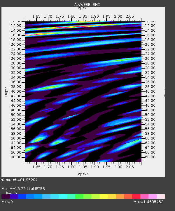
| Estimated Moho Depth: |
15.75 km |
| Estimated Crust Vp/Vs: |
1.60 |
| Assumed Crust Vp: |
5.989 km/s |
| Estimated Crust Vs: |
3.743 km/s |
| Estimated Crust Poisson's Ratio: |
0.18 |
|
| Radial Match: |
81.95204 % |
| Radial Bump: |
400 |
| Transverse Match: |
75.642944 % |
| Transverse Bump: |
400 |
| SOD ConfigId: |
31937991 |
| Insert Time: |
2023-09-11 20:02:54.170 +0000 |
| GWidth: |
2.5 |
| Max Bumps: |
400 |
| Tol: |
0.001 |
|

Signal To Noise
| Channel | StoN | STA | LTA |
| AV:WESE: :BHZ:20230828T20:07:00.479997Z | 12.969359 | 7.694617E-6 | 5.93292E-7 |
| AV:WESE: :BHN:20230828T20:07:00.479997Z | 4.5530963 | 2.5725237E-6 | 5.6500534E-7 |
| AV:WESE: :BHE:20230828T20:07:00.479997Z | 5.4575315 | 2.8372417E-6 | 5.198764E-7 |
| Arrivals |
| Ps | 1.6 SECOND |
| PpPs | 6.7 SECOND |
| PsPs/PpSs | 8.3 SECOND |


