You are here: Home > Network List > TA - USArray Transportable Network (new EarthScope stations) Stations List
> Station J19A Crowheart, WY, USA > Earthquake Result Viewer
J19A Crowheart, WY, USA - Earthquake Result Viewer
| Earthquake location: |
Near Coast Of Central Chile |
| Earthquake latitude/longitude: |
-38.1/-73.3 |
| Earthquake time(UTC): |
2010/07/14 (195) 08:32:21 GMT |
| Earthquake Depth: |
22 km |
| Earthquake Magnitude: |
5.9 MB, 6.5 MS, 6.6 MW, 6.5 MW |
| Earthquake Catalog/Contributor: |
WHDF/NEIC |
|
| Network: |
TA USArray Transportable Network (new EarthScope stations) |
| Station: |
J19A Crowheart, WY, USA |
| Lat/Lon: |
43.26 N/109.05 W |
| Elevation: |
1782 m |
|
| Distance: |
87.2 deg |
| Az: |
334.709 deg |
| Baz: |
152.509 deg |
| Ray Param: |
0.043464772 |
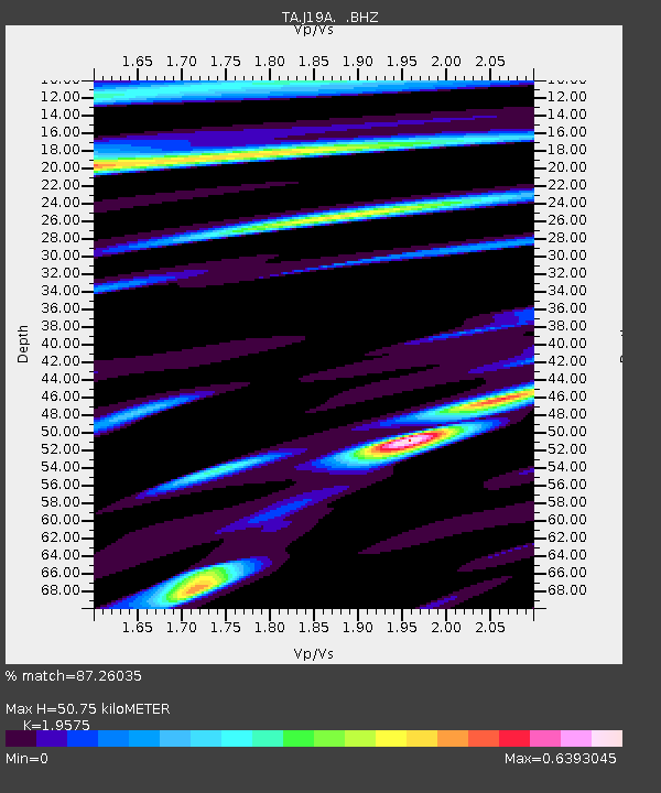
| Estimated Moho Depth: |
50.75 km |
| Estimated Crust Vp/Vs: |
1.96 |
| Assumed Crust Vp: |
6.161 km/s |
| Estimated Crust Vs: |
3.147 km/s |
| Estimated Crust Poisson's Ratio: |
0.32 |
|
| Radial Match: |
87.26035 % |
| Radial Bump: |
400 |
| Transverse Match: |
79.126305 % |
| Transverse Bump: |
400 |
| SOD ConfigId: |
319893 |
| Insert Time: |
2011-01-05 03:03:56.285 +0000 |
| GWidth: |
2.5 |
| Max Bumps: |
400 |
| Tol: |
0.001 |
|
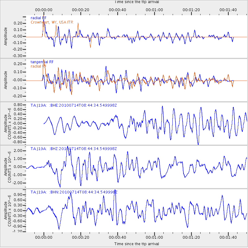
Signal To Noise
| Channel | StoN | STA | LTA |
| TA:J19A: :BHZ:20100714T08:44:34.549998Z | 3.303165 | 3.4247407E-7 | 1.03680584E-7 |
| TA:J19A: :BHN:20100714T08:44:34.549998Z | 1.1698147 | 1.47889E-7 | 1.2642087E-7 |
| TA:J19A: :BHE:20100714T08:44:34.549998Z | 0.5670252 | 1.0817442E-7 | 1.9077532E-7 |
| Arrivals |
| Ps | 8.0 SECOND |
| PpPs | 24 SECOND |
| PsPs/PpSs | 32 SECOND |


