You are here: Home > Network List > JP - Japan Meteorological Agency Seismic Network Stations List
> Station JOW Okinawa Kunigami > Earthquake Result Viewer
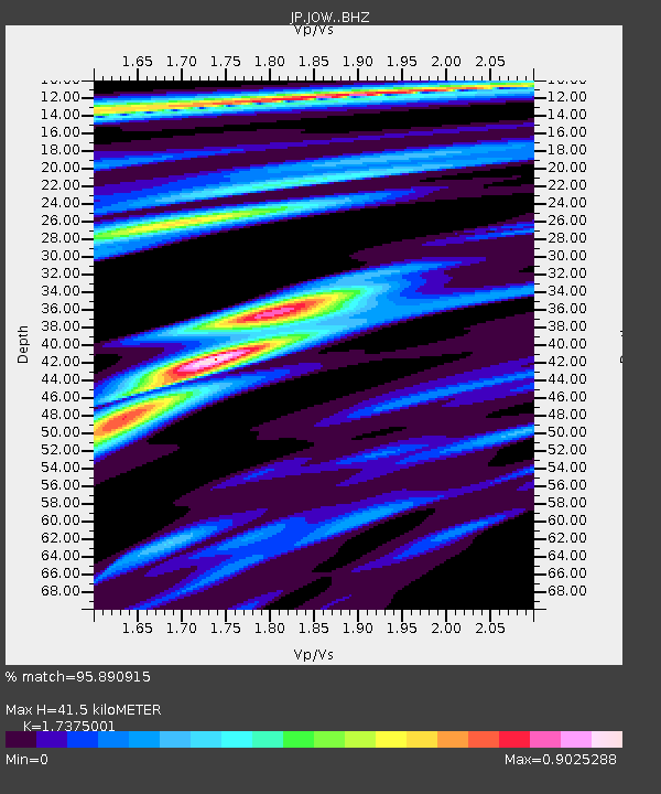
JOW Okinawa Kunigami - Earthquake Result Viewer
| Earthquake location: |
Bali Sea |
| Earthquake latitude/longitude: |
-6.8/116.5 |
| Earthquake time(UTC): |
2023/08/28 (240) 19:55:31 GMT |
| Earthquake Depth: |
514 km |
| Earthquake Magnitude: |
7.1 Mww |
| Earthquake Catalog/Contributor: |
NEIC PDE/us |
|
| Network: |
JP Japan Meteorological Agency Seismic Network |
| Station: |
JOW Okinawa Kunigami |
| Lat/Lon: |
26.84 N/128.27 E |
| Elevation: |
220 m |
|
| Distance: |
35.3 deg |
| Az: |
18.312 deg |
| Baz: |
200.438 deg |
| Ray Param: |
0.0748511 |
| Estimated Moho Depth: |
41.5 km |
| Estimated Crust Vp/Vs: |
1.74 |
| Assumed Crust Vp: |
6.183 km/s |
| Estimated Crust Vs: |
3.558 km/s |
| Estimated Crust Poisson's Ratio: |
0.25 |
|
| Radial Match: |
95.890915 % |
| Radial Bump: |
233 |
| Transverse Match: |
74.190605 % |
| Transverse Bump: |
400 |
| SOD ConfigId: |
31937991 |
| Insert Time: |
2023-09-11 20:06:12.958 +0000 |
| GWidth: |
2.5 |
| Max Bumps: |
400 |
| Tol: |
0.001 |
|

Signal To Noise
| Channel | StoN | STA | LTA |
| JP:JOW: :BHZ:20230828T20:01:12.800004Z | 5.9305115 | 2.8131883E-6 | 4.7435844E-7 |
| JP:JOW: :BHN:20230828T20:01:12.800004Z | 2.5900927 | 1.2503474E-6 | 4.827424E-7 |
| JP:JOW: :BHE:20230828T20:01:12.800004Z | 1.8766582 | 6.9335226E-7 | 3.6946113E-7 |
| Arrivals |
| Ps | 5.3 SECOND |
| PpPs | 17 SECOND |
| PsPs/PpSs | 22 SECOND |


