You are here: Home > Network List > TA - USArray Transportable Network (new EarthScope stations) Stations List
> Station D22A Cohagen, MT, USA > Earthquake Result Viewer
D22A Cohagen, MT, USA - Earthquake Result Viewer
| Earthquake location: |
Near Coast Of Central Chile |
| Earthquake latitude/longitude: |
-38.1/-73.3 |
| Earthquake time(UTC): |
2010/07/14 (195) 08:32:21 GMT |
| Earthquake Depth: |
22 km |
| Earthquake Magnitude: |
5.9 MB, 6.5 MS, 6.6 MW, 6.5 MW |
| Earthquake Catalog/Contributor: |
WHDF/NEIC |
|
| Network: |
TA USArray Transportable Network (new EarthScope stations) |
| Station: |
D22A Cohagen, MT, USA |
| Lat/Lon: |
47.15 N/106.18 W |
| Elevation: |
791 m |
|
| Distance: |
89.8 deg |
| Az: |
338.258 deg |
| Baz: |
154.635 deg |
| Ray Param: |
0.041717857 |
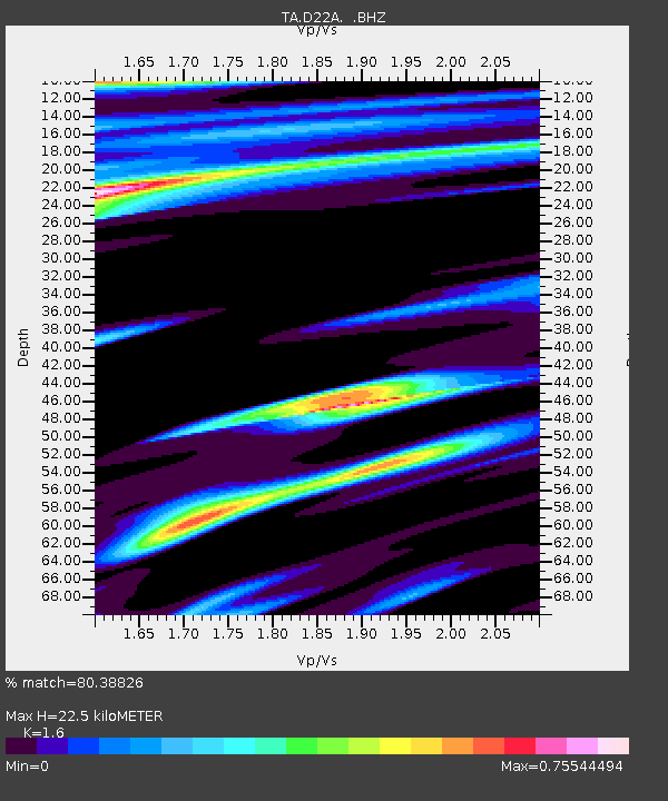
| Estimated Moho Depth: |
22.5 km |
| Estimated Crust Vp/Vs: |
1.60 |
| Assumed Crust Vp: |
6.438 km/s |
| Estimated Crust Vs: |
4.023 km/s |
| Estimated Crust Poisson's Ratio: |
0.18 |
|
| Radial Match: |
80.38826 % |
| Radial Bump: |
400 |
| Transverse Match: |
59.432785 % |
| Transverse Bump: |
400 |
| SOD ConfigId: |
319893 |
| Insert Time: |
2011-01-05 03:05:02.053 +0000 |
| GWidth: |
2.5 |
| Max Bumps: |
400 |
| Tol: |
0.001 |
|
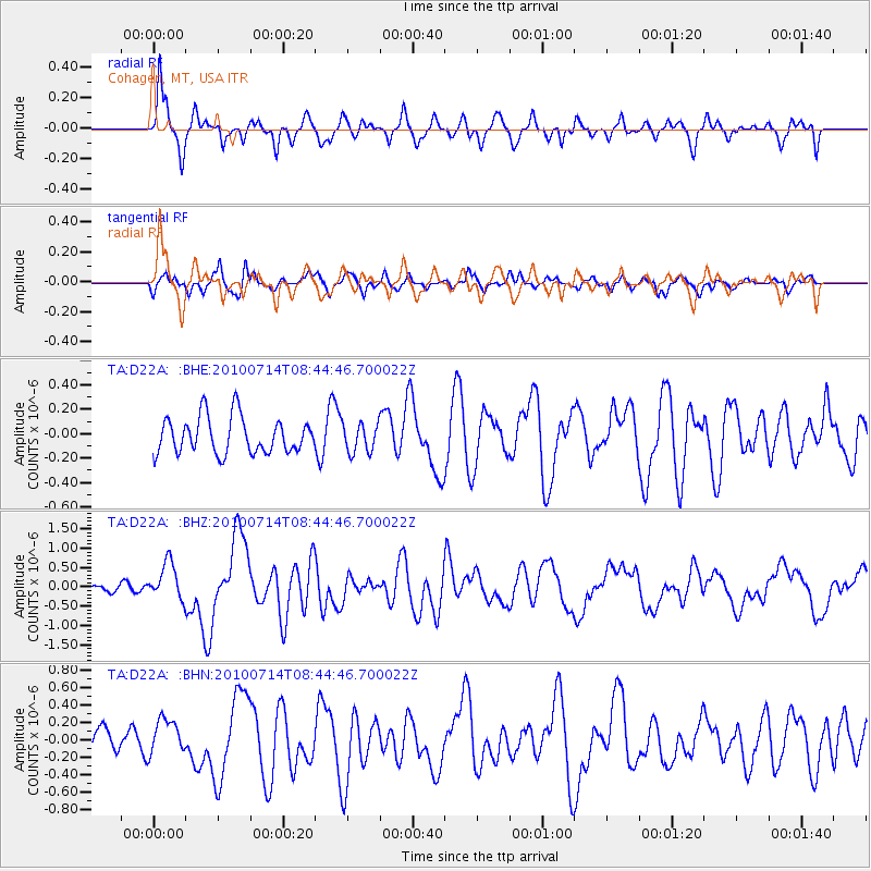
Signal To Noise
| Channel | StoN | STA | LTA |
| TA:D22A: :BHZ:20100714T08:44:46.700022Z | 5.257562 | 4.790567E-7 | 9.1117656E-8 |
| TA:D22A: :BHN:20100714T08:44:46.700022Z | 0.9224445 | 2.0208154E-7 | 2.1907175E-7 |
| TA:D22A: :BHE:20100714T08:44:46.700022Z | 0.7970242 | 1.17954734E-7 | 1.4799392E-7 |
| Arrivals |
| Ps | 2.1 SECOND |
| PpPs | 8.9 SECOND |
| PsPs/PpSs | 11 SECOND |


