You are here: Home > Network List > US - United States National Seismic Network Stations List
> Station DGMT Dagmar, Montana, USA > Earthquake Result Viewer
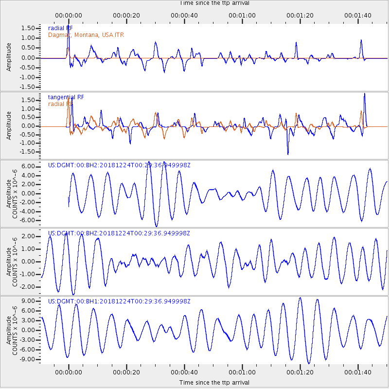
DGMT Dagmar, Montana, USA - Earthquake Result Viewer
*The percent match for this event was below the threshold and hence no stack was calculated.
| Earthquake location: |
Off East Coast Of Honshu, Japan |
| Earthquake latitude/longitude: |
34.1/141.8 |
| Earthquake time(UTC): |
2018/12/24 (358) 00:18:05 GMT |
| Earthquake Depth: |
18 km |
| Earthquake Magnitude: |
5.6 Mww |
| Earthquake Catalog/Contributor: |
NEIC PDE/us |
|
| Network: |
US United States National Seismic Network |
| Station: |
DGMT Dagmar, Montana, USA |
| Lat/Lon: |
48.47 N/104.20 W |
| Elevation: |
0.0 m |
|
| Distance: |
78.9 deg |
| Az: |
38.291 deg |
| Baz: |
309.376 deg |
| Ray Param: |
$rayparam |
*The percent match for this event was below the threshold and hence was not used in the summary stack. |
|
| Radial Match: |
48.050674 % |
| Radial Bump: |
383 |
| Transverse Match: |
54.97637 % |
| Transverse Bump: |
283 |
| SOD ConfigId: |
3201911 |
| Insert Time: |
2019-01-07 00:23:31.775 +0000 |
| GWidth: |
2.5 |
| Max Bumps: |
400 |
| Tol: |
0.001 |
|
Signal To Noise
| Channel | StoN | STA | LTA |
| US:DGMT:00:BHZ:20181224T00:29:36.949998Z | 2.1199486 | 1.8009022E-6 | 8.495027E-7 |
| US:DGMT:00:BH1:20181224T00:29:36.949998Z | 1.2110709 | 5.847389E-6 | 4.82828E-6 |
| US:DGMT:00:BH2:20181224T00:29:36.949998Z | 1.7249254 | 4.922998E-6 | 2.8540353E-6 |
| Arrivals |
| Ps | |
| PpPs | |
| PsPs/PpSs | |


